Wingcopter Expands Its Capabilities for Long-Range LiDAR Surveying
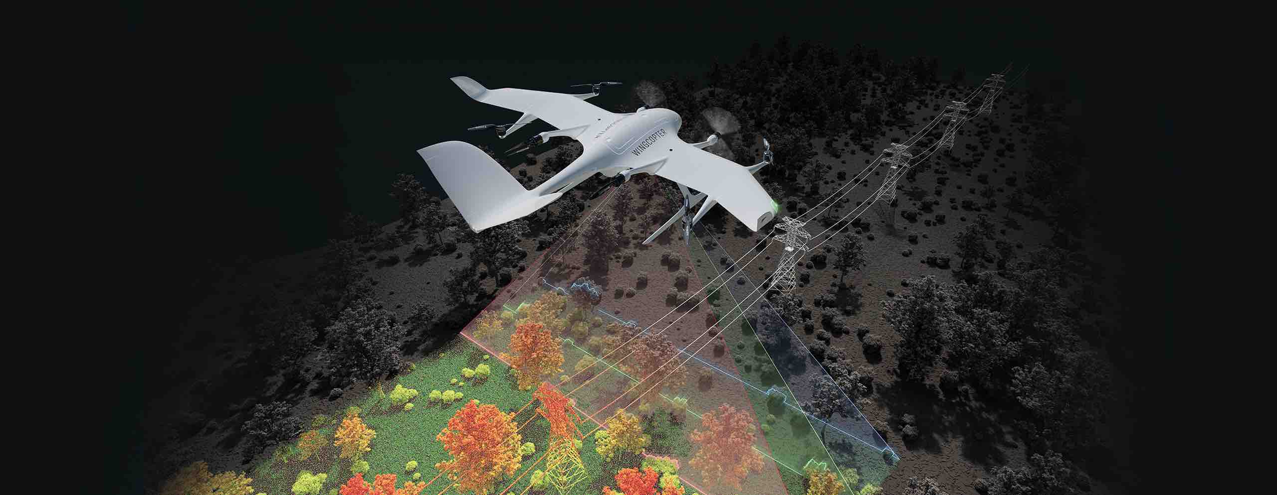
Wingcopter, the German drone maker renowned for its cargo drones, has announced an exciting extension of its product line to include long-range BVLOS (Beyond Visual Line of Sight) LiDAR surveying solutions. This development is set to enhance the capabilities of the Wingcopter 198, which will now be outfitted with advanced laser scanning and camera systems, allowing for quick and efficient collection of high-quality data.
The new system is designed to enable users to survey up to an impressive 37 miles (60 km) of linear infrastructure in a single mission, accommodating a sensor payload of 10 lbs (4.5 kg). Ideal applications include inspecting power lines, pipelines, railroads, and roads, as well as mapping complex terrains and vegetation that are difficult to access.

This announcement occurred during GEO WEEK in Denver, Colorado—a prominent event in the geospatial technology sector—where Wingcopter is prominently presenting its innovative application. The upgraded system promises to achieve up to 570 points per square meter with a sensor accuracy of 10 mm and a precision of 5 mm, significantly surpassing current market offerings. By utilizing a Wingcopter outfitted with high-quality LiDAR technology, customers can scan up to 2,560 acres (10.3 square kilometers) in just one 42-minute BVLOS mission.
Ansgar Kadura, Co-Founder and Chief Strategy Officer at Wingcopter, emphasized the company’s dedication: “After years of development and rigorous testing, we have finalized the configuration of the Wingcopter 198 that is presently undergoing FAA type certification in the U.S. Features like unique payloads and range capabilities, alongside over 1,000 flight hours of proven reliability, position it as one of the most dependable long-range electric Vertical Take-Off and Landing (eVTOL) Unmanned Aerial Systems (UAS) available. We intend to tailor solutions for high-quality LiDAR surveying and integrate leading sensor technologies for comprehensive surveying capabilities.”
Interest in this technology is particularly strong in Brazil. Synerjet, Wingcopter’s authorized local partner, is looking to deploy fleets of Wingcopter 198 drones within the surveying industry.
Augustinho Simoes, Director of Drone Operations and Development at Synerjet, remarked, “We are collaborating with Wingcopter to develop customized applications that enhance aircraft functionality and meet diverse industry requirements, including asset inspections, vegetation monitoring, and effective mapping strategies. The initial model will feature a sophisticated LiDAR sensor, which boasts an extensive 100-degree field of view and a remarkably high pulse repetition rate of up to 2.4 MHz. This advanced measuring technology will emit pulses in three distinct directions, ensuring comprehensive data collection, especially in complex environments with vertical surfaces, narrow canyons, power lines, railroads, highways, and forestry applications.”
For further updates on Wingcopter’s advancements and insights into the applications of drone technology, keep an eye on industry news.
Related Articles:
L3Harris Launches New Technology to Control Autonomous Swarms
American Robotics Secures BVLOS Waiver for Remote Operations Center-Based Drone Flights