Utilizing Drone Technology and LiDAR for Resilient Town Planning in African Cities Against Natural Disasters
The impact of climate change is increasingly evident in rapidly urbanizing African cities. Events such as floods, droughts, and cyclones bring extensive disruptions, affecting lives and infrastructure. Urban planners are now adopting cutting-edge technologies like drone technology and LiDAR (Light Detection and Ranging) to enhance urban resilience. These tools assist in crafting city designs that can better endure climate-related challenges, ultimately paving the way for safer communities.
Understanding Drone Technology and LiDAR
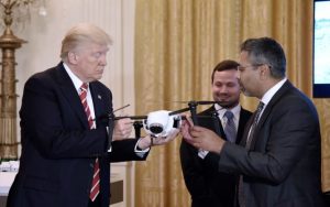
Drone technology, specifically unmanned aerial vehicles (UAVs), has revolutionized various industries. Drones provide high-resolution aerial imagery and streamline data collection. When paired with LiDAR, which accurately measures distances using laser scanning, they facilitate quick and precise mapping of landscapes, structures, and vegetation.
For urban planners, the integration of drones and LiDAR signifies a major advancement in town planning. With these tools, planners can gather extensive datasets to make informed decisions. A study indicated that implementing drones in mapping reduced project duration by up to 75%, greatly improving a city’s disaster response capabilities.
The Need for Resilient Town Planning in African Cities
African cities encounter distinctive challenges that elevate their vulnerability to climate change effects. Financial limitations, rapid urbanization, and inadequate infrastructure compound this susceptibility. Thus, effective town planning must proactively address threats posed by extreme weather.
Flooding emerges as a critical issue for many African cities. Research has shown that in areas prone to flooding, informal settlements account for 60% of the urban population in places like Dar es Salaam, Tanzania. Drones equipped with LiDAR are capable of generating precise flood risk maps, enabling planners to identify high-risk zones and develop efficient drainage systems to safeguard these communities.
Enhancing Data Collection for Evidence-Based Planning
The rapid data collection capabilities of drone technology represent a unique strength, often surpassing traditional methods. Drones can reach inaccessible areas, providing detailed topographical mapping in hours rather than the weeks or months required for ground surveys.
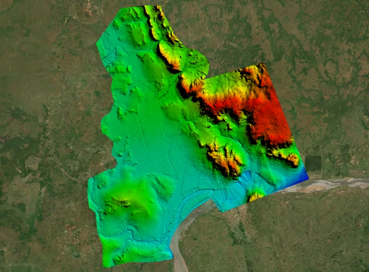
LiDAR technology delivers high-resolution elevation data, capturing even minor changes in the landscape. This data is vital for urban planners to comprehend water flow patterns, anticipate flood trends, and implement flood prevention strategies. For instance, after employing LiDAR analytics, a city could see a 40% decrease in flood damage claims over the next five years.
Monitoring Urban Development and Changes Over Time
As cities continuously evolve, so do their risk profiles. Urban planners must effectively monitor changes to evaluate potential risks. Drones can be utilized for regular aerial surveys, offering consistent perspectives on urban expansion, infrastructure alterations, and environmental shifts over time.
Information sourced from these surveys can assist in assessing ecosystem health and pinpointing areas that require immediate attention due to climate-related threats. For example, urban planners in Cape Town, South Africa, used drone technology to identify over 1,000 hectares of land suitable for reforestation, aiding both flood management and carbon offsetting efforts.
Case Studies: Successful Applications of Drone Technology in African Cities
Several African cities are already leveraging drone technology and LiDAR for urban planning advancements.
For instance, in Kigali, Rwanda, UAVs played a crucial role in developing detailed city maps that significantly enhanced land management and disaster preparedness. The analysis of elevation and topographical data has permitted city planners to implement strategies that have halved flood risks compared to earlier years.
Similarly, in Tanzania, drone surveys have been vital in identifying regions most susceptible to flooding. This data has enabled local authorities to prioritize infrastructure investments, leading to a reported 35% decrease in flood occurrences in previously affected areas after necessary improvements.
Facilitating Community Engagement and Awareness
The employment of drone technology and LiDAR extends beyond technical applications; it also promotes community engagement. By using high-quality aerial imagery, urban planners can develop clear visual representations that simplify complex data for community members.
Such visual tools prove invaluable during discussions concerning land usage, high-risk zones, and potential interventions. As community members gain a better understanding of the data, they can become more engaged in the planning processes. This proactive involvement fosters trust between city officials and residents, nurturing the collaborative environment essential for effective climate adaptability in urban regions.
Future Directions for Drone Technology in Town Planning
The incorporation of drone technology and LiDAR within town planning is still in its infancy. As these technologies continue to advance, their applications in urban planning are anticipated to grow significantly.
The integration of artificial intelligence (AI) into drone data analysis could further amplify the predictive capabilities concerning natural disaster impacts on cities. For example, AI algorithms could assess temporal data to forecast flooding patterns, allowing urban planners to proactively identify risks and adapt their strategies accordingly.
Furthermore, with more training programs being introduced, an increasing number of urban planners will acquire the skills to leverage these technologies, enhancing their capacity to create safer, more resilient urban environments across Africa.
Final Thoughts
As the repercussions of climate change intensify, adopting drone technology and LiDAR in urban planning emerges as a crucial strategy for fostering resilience in African cities. The valuable data and insights derived from these technologies enable the development of well-informed and effective strategies that shield communities from the threats posed by natural disasters.
By embracing innovative solutions over outdated methods, urban planners can transform obstacles into opportunities. The ultimate objective is not merely to endure the effects of climate change but to thrive, cultivating sustainable and resilient urban spaces that safeguard all residents. Embracing drone technology is fundamental to progressive urban planning that emphasizes safety, sustainability, and inclusivity in African cities.