Virtual Surveyor Enhances Drone Surveying Software with Topographic Design Tools
Virtual Surveyor has introduced Basic Topographic Design tools in Version 10 of its smart drone surveying software, enabling users to design key terrain features such as graded roads, ponds, and flat surfaces directly onto their survey data. This update is based on the innovative integration of time-based concepts, allowing for a more accurate visualization of future topographic changes.
The software has previously supported a comprehensive workflow for 3D surveys utilizing drone imagery, organized into subscription tiers: Valley (free), Ridge, and Peak. Each tier progressively enhances capabilities for creating detailed survey products using UAV images and LiDAR data.
A new tier, Mountain, has been added between Ridge and Peak, categorizing its features based on temporal considerations. For instance, the Ridge plan allows for surveying data from a single point in time, while the Mountain plan introduces Timelines to facilitate comparisons across multiple surveys taken at different times. The Peak plan now adds Topographic Design functions to create planned structures for future development.
According to Tom Op ‘t Eyndt, CEO of Virtual Surveyor, “The new Topographic Design tools in the Peak plan were developed for engineering surveyors to design rock walls, roads, or ponds in the current landscape for various projects like excavations, mining, and construction. Designs can be exported in formats that are compatible with machinery used for earth-moving tasks.”
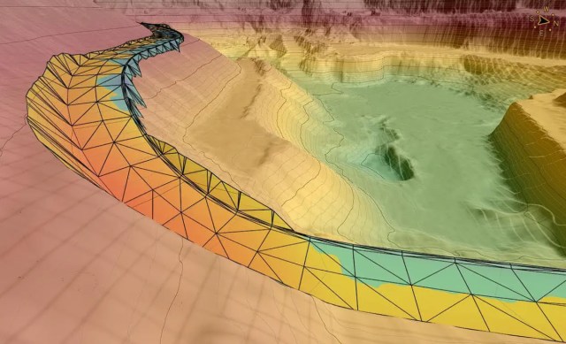
With the Peak plan’s Topographic Design capabilities, engineering surveyors can effectively plan new features, adding designated Time Steps to the Timeline. Users simply outline the future construction on the UAV-derived orthophoto or elevation model, and the software aligns it seamlessly with the surrounding terrains. The cut-and-fill tool calculates the necessary alterations in soil or rock volume to achieve the desired design.
The latest update also features several enhancements:
- The Ridge plan and higher tiers include Drawing Guides that allow for precise plotting of points and angles.
- The Mountain plan’s Timelines enable comparison of surveys over time, allowing for visualizations of changes in both 2D maps and 3D elevation profiles.
- All subscription plans now incorporate a Walk Mode, enabling users to explore 3D surveys in a more immersive manner.
“With Walk Mode, Virtual Surveyor users can explore past, current, and future terrains from various drone surveys, making the design phase an interactive experience,” added Op ‘t Eyndt.
For those eager to try Virtual Surveyor, a free 14-day trial is available, alongside details for the Valley, Ridge, Mountain, and Peak pricing plans at www.virtual-surveyor.com.
About Virtual Surveyor
Virtual Surveyor software empowers professional surveyors to derive accurate topographic products from drone imagery at speeds five times greater than conventional methods. Utilized in 88 countries, this software rapidly generates topographic data from UAV inputs, converting them into interactive virtual environments where surveyors can select significant survey points and breaklines. Typical outputs include surfaces, TINs (Triangular Irregular Networks), contours, line surveys, stockpile reports, and cut-and-fill maps applicable in various engineering and design projects.