Virtual Surveyor Enhances Drone Surveying Software with Topographic Design Features
On March 12, 2025, Virtual Surveyor [http://www.virtual-surveyor.com/] announced the introduction of Basic Topographic Design tools in version 10 of its innovative drone surveying software. These new features will enable users to create simple terrain modifications, such as graded roads, ponds, and flat building surfaces directly on their surveys. This update aims to provide users with an accurate visualization of future topographies by incorporating the concept of time into the software’s functionality.
Traditionally, Virtual Surveyor has offered an end-to-end workflow for conducting 3D surveys using drone imagery, categorized into subscription plans: Valley, Ridge, and Peak. The Valley plan serves as a free introductory option, while the Ridge and Peak plans provide advanced capabilities for generating 3D survey products from UAV imagery and LiDAR data.
Version 10 introduces a new Mountain plan, positioned between the Ridge and Peak plans, with an emphasis on time-based comparisons. The Ridge plan is designed for surveying a single moment with one drone data set, while the Mountain plan incorporates Timelines, allowing users to compare multiple surveys taken at different times. The Peak plan now features Topographic Design functions meant for creating structures intended for future installation.
According to Tom Op ‘t Eyndt, CEO of Virtual Surveyor, “The newly added Topographic Design tools in the Peak plan were specifically developed for engineering surveyors. These tools allow for the design of rock walls, roads, and ponds within existing terrains for projects related to excavation, mining, quarries, water management, and construction.” Users can export their designs into machine model formats compatible with software that drives bulldozers, graders, and other earth-moving machinery.
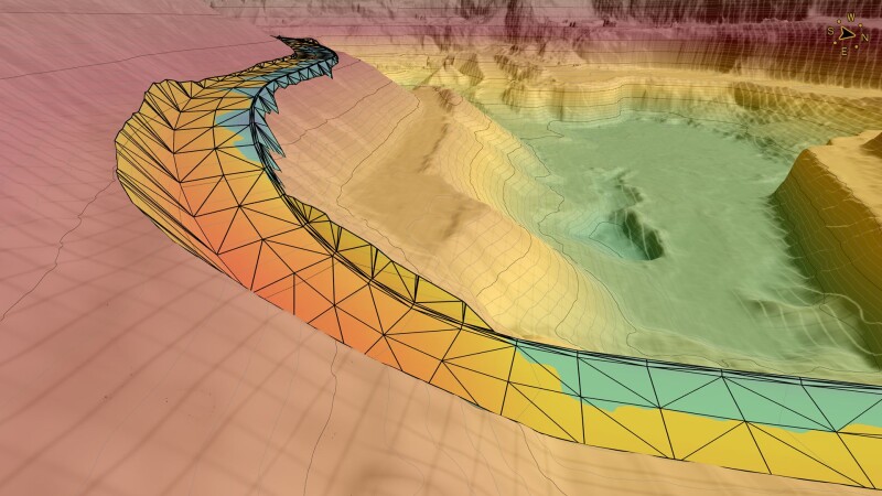
The Topographic Design capabilities within the Peak plan empower engineering surveyors to plan new features and create Time Steps on the Timeline. Users can draw upcoming structures on baseline UAV-derived orthophotos or elevation models. The software efficiently adjusts the angles and alignment to seamlessly integrate the planned features with the surrounding terrain. Additionally, the existing cut-and-fill tool calculates the volume of earth or rock needed to realize the future design.
Version 10 of Virtual Surveyor also includes other enhancements, such as:
- Drawing Guides: Available in the Ridge plan and above, these guides assist users in drawing points on lines at specified intervals (e.g., every 5m or 10m) and drawing angles precisely (45 or 90 degrees).
- Timelines: The Mountain plan allows users to organize and analyze drone data over time, comparing multiple surveys from different dates to visualize changes in both 2D map view and 3D elevation profiles. Future structures can also be integrated into the Timeline using Design tools.
- Walk Mode: All subscription plans, including the complimentary Valley plan, now feature Walk Mode, which enables users to navigate through the 3D survey and observe the terrain from a ground-level perspective.
Op ‘t Eyndt concluded, “Virtual Surveyor users can utilize Walk Mode to experience 3D terrains from both past and present drone surveys while envisioning future topographies during the design process.”
For a complimentary 14-day trial of Virtual Surveyor and detailed pricing information for the Valley, Ridge, Mountain, and Peak plans, visit www.virtual-surveyor.com.
About Virtual Surveyor: Virtual Surveyor software empowers professional surveyors to produce accurate topographic outputs from drone imagery up to five times faster than conventional fieldwork, delivering a fully integrated workflow. Now operational in 88 countries, Virtual Surveyor transforms drone data into topographic information efficiently. The software generates orthomosaics and digital surface models (DSMs) from UAV images and facilitates the selection of survey points and breaklines for topography definition within an interactive virtual environment. Outputs from the software include Surfaces or TINs (Triangular Irregular Networks), Contour maps, Line Surveys, Stockpile Reports, and Cut-and-Fill Maps for various engineering design applications.
Source: Press Release