Photogrammetry vs. LiDAR: Choosing the Right Tool for the Job, with Dr. Philippe Simard
Mapping the world in stunning 3D involves two main technologies: photogrammetry and LiDAR. Although their goal of accurate terrain mapping aligns, the methods they use differ significantly. Dr. Philippe Simard, CEO of SimActive and a leader in geospatial data processing, offers insights into these technologies to help you make informed choices.
The Basics: How Photogrammetry and LiDAR Work
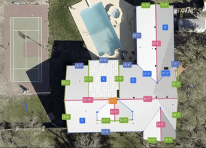
Photogrammetry involves extracting 3D information from photographs. By deploying a camera drone to capture overlapping images from various angles, specialized software—such as SimActive’s Correlator3D™—can reconstruct the landscape into a dense, color-accurate 3D model. This is made possible through advanced computer vision techniques.
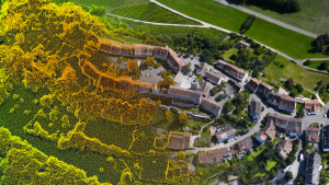
LiDAR (Light Detection and Ranging) operates on a principle of laser precision. The LiDAR sensor emits laser pulses towards the ground and measures the time it takes for them to reflect back. This allows for the creation of an exact 3D map, capable of penetrating dense vegetation and operating in the dark.
Key Differences at a Glance
| Feature | Photogrammetry | LiDAR |
|---|---|---|
| Sensor Type | Passive (camera) | Active (laser) |
| Data Output | Photorealistic, color point clouds | High-density point clouds (optional RGB) |
| Performance in Vegetation | Struggles with dense cover | Excels—can “see through” canopy |
| Preferred Lighting | Requires good ambient light | Works in darkness |
| Cost & Accessibility | Lower-cost, uses camera drones | Higher-cost, specialized equipment |
| Expertise Required | Easier entry for drone operators | Advanced, more technical know-how |
| Visual Appeal | Natural texturing and color | Geometric accuracy, less vivid visuals |
| Coverage Efficiency | Efficient for open/large areas | Highly efficient for terrain/vegetation |
Expert Perspective: Dr. Philippe Simard Weighs In
Dr. Simard explains that both technologies are notably accurate when applied properly. “Photogrammetry shines in large-scale projects with its speedy data collection and vivid visual output. Both achieve similar accuracy levels, but LiDAR excels in vegetated areas, while photogrammetry offers scalable solutions for bigger regions.”
Choosing the best tool depends on the project: photogrammetry is ideal for open fields and urban settings, whereas LiDAR is optimal for dense forests and rugged areas.
Photogrammetry: When Visual Detail Matters Most
Use cases: Construction site monitoring, urban planning, mining, and cultural heritage preservation.
Photogrammetry is accessible due to modern software capabilities which transform almost any drone camera into a potent mapping device. However, challenges arise in dense vegetation and low lighting conditions, requiring substantial image processing and potentially ground control points for precision.
LiDAR: Seeing the Ground Through the Trees
Use cases: Forestry, topographic mapping under tree cover, corridor mapping, and disaster response.
LiDAR is distinguished by its ability to penetrate leafy canopies, providing precise bare-earth models even in low-light scenarios. Despite its higher costs and technical demands, it remains unparalleled in specific environments.
Accuracy and Integration: Not Either/Or—But Sometimes Both
Both approaches can achieve centimeter-level accuracy given the right conditions. Platforms like SimActive’s Correlator3D™ enable the fusion of LiDAR and photogrammetry, creating well-aligned, color-enhanced 3D models and reducing manual work onsite.
Real-World Examples & Client Success
Dr. Simard’s software aids mapping tasks globally, from disaster response to urban planning. For instance, LiDAR is employed for flood mapping while photogrammetry adds detailed visual textures, illustrating the technologies’ complementary benefits.
Choosing What’s Right: Key Decision Factors
A practical checklist derived from Dr. Simard’s and industry insights:
- Dense Vegetation: Opt for LiDAR, or augment photogrammetry with LiDAR ground control.
- Realistic Visuals: Photogrammetry offers more natural color models.
- Budget Concerns or Existing Equipment: Photogrammetry is more economical.
- Need for Speed: Photogrammetry is fast for open spaces; LiDAR excels in complex terrains.
- Large-scale Projects: Consider hybrid approaches or expert advice for effective integration.
Future Trends: Where Photogrammetry and LiDAR Meet
The divide between LiDAR and photogrammetry is narrowing. With advancements in sensor technology and integration software, the next era favors the use of both data sources for comprehensive, precise mapping projects.
A Human Touch: The SimActive Approach
Dr. Simard and SimActive focus on pushing the limits of geospatial technology while ensuring accessibility—helping users from novices to experts solve real-world problems and tell stories through data.
“We aim to be a trusted partner for every mapping mission—no matter how complex,” reflects Dr. Simard.
Conclusion: The Wisdom of Choice
Each technology offers unique advantages based on the project’s requirements. Selecting the right tool begins with understanding your objectives and the strengths of each method. As industry leaders remind us, effective mapping involves harnessing these technologies to their fullest potential.
Whether charting wild landscapes, designing urban futures, or producing stunning 3D models, remember: with the right tools, the journey doesn’t end at the sky, it begins there.
Elevate your mapping mission by consulting experts and leveraging cutting-edge software. The combination of photogrammetry and LiDAR often delivers the most robust results.