Next-Gen Sensor Fusion Avionics: Enhancing Safety in Degraded Visual Conditions
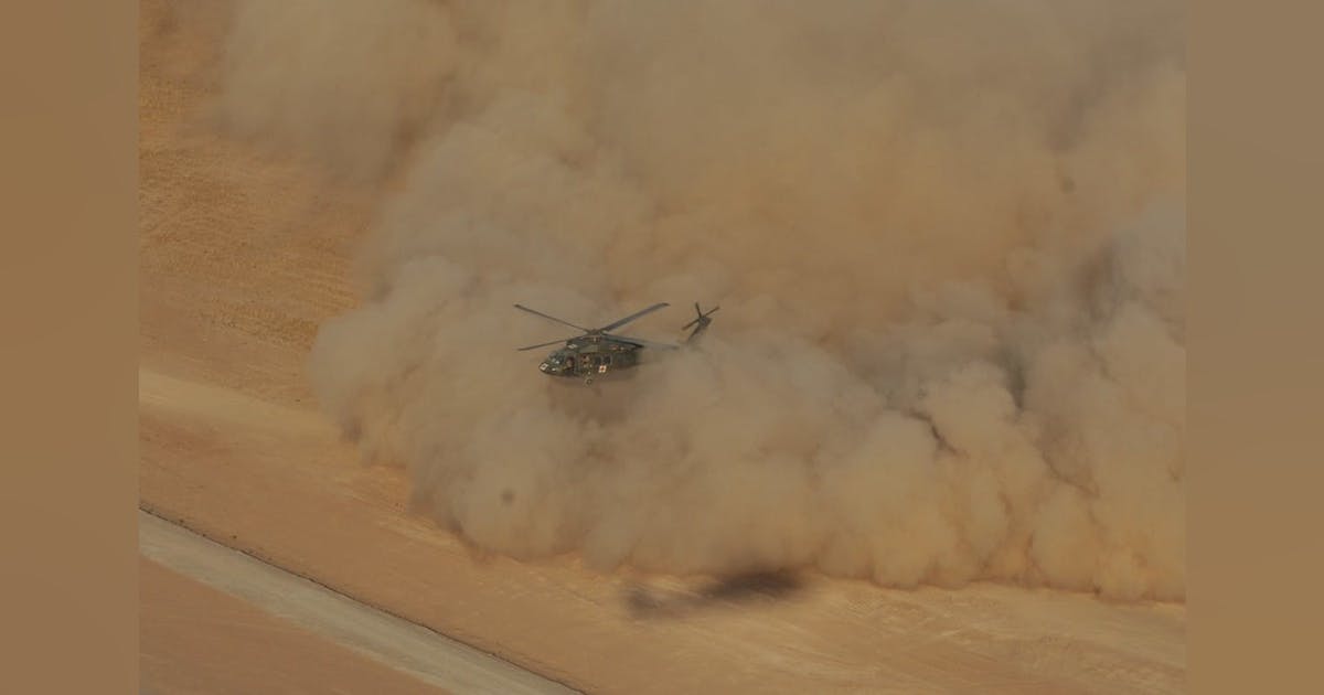
Imagine a helicopter landing amidst swirling dust, snow, or darkness. In these conditions, seeing is nearly impossible, yet missions can’t be postponed. Now, a technology emerges that not only restores visual capability for pilots but enhances it with a synthetic 360-degree view exceeding human limitations. Welcome to the forefront of military aviation: sensor fusion avionics by Sierra Nevada Corporation (SNC), crafted for elite U.S. forces.
Why Degraded Visual Conditions Pose a Challenge
Pilots operating in military and special operations frequently encounter degraded visual environments (DVE) such as ‘brownouts’ from dust, ‘whiteouts’ from snow, fog, smoke, and darkness. These scenarios can blind pilots during critical moments like takeoffs, landings, or while flying over complex terrains. Losing visual cues is more than a nuisance; it’s a primary accident cause in military aviation, directly linked to incidents in recent conflicts.
According to Dean Heitkamp, SNC’s senior director and a former military pilot, ‘Whiteouts and brownouts heighten danger when many helicopters focus on the same area, exacerbating dust clouds as more arrive. Even with advanced training, landing in such zero-visibility situations is hazardous— absent any combat threats.’
The Solution: Sensor Fusion Technology
No single sensor effectively ‘sees’ through all DVE conditions: FLIR cameras illuminate warm objects but get ‘blinded’ by dust or snow; millimeter-wave radar pierces through dust and fog but with lower image quality; LiDAR creates accurate 3D outlines yet struggles against harsh weather or dust clouds. Mitigation demands merging these technologies—sensor fusion.
How Sierra Nevada’s DVEPS Operates
The “Avionic Superpower”: Sensor Fusion
Sierra Nevada’s Degraded Visual Environment Pilotage System (DVEPS) combines FLIR, MMW radar, and LiDAR with digital terrain databases, producing a ‘synthetic 3D world’ around helicopters. Key components include multiple sensors, a fusion computer for geo-referencing sensor data, helmet-mounted and cockpit displays projecting a synthetic panorama into pilots’ views, and guidance algorithms for safe navigation despite visibility challenges.
This isn’t fiction: the system relies on robust, real-time platforms like the INTEGRITY-178 tuMP RTOS, processing and displaying fused sensor data instantaneously.

Real-World Impact: Safety in Operations
Consider these real scenarios: During an Afghanistan mission in 2012, a medevac team landed at night on a dust-filled valley floor, experiencing ‘brownout’ as visuals vanished. Despite this, DVEPS equips pilots with a real-time synthetic 3D view, highlighting obstacles. In Arctic rescue, a Chinook helicopter navigating a ‘whiteout’ utilized LiDAR and radar for stabilized landing.
| Feature | Details & Impact |
|---|---|
| Sensors Integrated | FLIR, MMW Radar, LiDAR, Digital Terrain |
| Display Options | Helmet-mounted (HUD), Cockpit panel |
| Key Benefits | Safe landings in DVE, 360° awareness, real-time obstacle detection |
| Supported Helicopters | UH-60 Black Hawk, CH-47 Chinook, AH-64 Apache, MH-60M, MH-47G, others |
| Civilian Applications | Medevac, SAR, utility helicopters soon |
| Contract Status | Through 2030, with SOCOM and U.S. Army |
| Core Tech | Real-time sensor fusion, open architecture, airworthiness certified |
Technological advancements like these mean safer missions, minimized aircraft loss, and saved lives.
The Technology Behind DVEPS
The core of Sierra Nevada’s success lies in its sensor fusion software, Sierra Fusion™, which integrates varied sensor feeds to craft a ‘common operating picture’ for on-ground and airborne teams. This software is scalable, with an open architecture and airworthiness certification (DO-178C DAL C). The mission computer hardware processes data and presents images through heads-up displays at ultra-low latency speeds under 100 milliseconds.
Reducing Pilot Workload
With its intuitive synthetic display, projected into helmets, DVEPS minimizes cognitive strain on pilots, allowing them to concentrate on critical tasks like flying over sifting through countless sensor inputs.
How DVEPS Differs from Traditional Synthetic Vision
Unlike standard synthetic vision relying on GPS and terrain data—prone to obsolescence—DVEPS augments reality, updating pilots with live changes and unexpected scenarios such as new obstacles in the flight path.
Adapting Commercially for Emergency Applications
Although developed for combat, this technology has immense implications for civilian settings. It offers benefits for medevac in fog or smoke-shrouded areas, and mountain rescue operations in blizzards. With future FAA certifications, these solutions could assist domestic emergency operations.
Expert Opinions
‘There’s no single sensor for all obscuring conditions. By fusing radar, infrared, and LiDAR, we ensure real-time world-model accuracy—impervious to nature or adversaries.’ — Dean Heitkamp, SNC Senior Director and former military pilot.
The Future of Aviation
SNC’s contract with U.S. Special Operations Command will persist until 2030, with possible extensions. Future developments may incorporate new sensors and interface with unmanned aerial systems, facilitating real-time data exchanges between coordinated platforms. The open architecture guarantees continuous system updates, ensuring long-term investment viability.
Sierra Nevada’s dedicated team, uniting professionals from various domains, aims to bolster mission success irrespective of obstacles, characterized by their collaboration with U.S. military forces.
Conclusion
With sensor fusion avionics like DVEPS, significant advancements in operational safety are achieved. Whether for special operations or civilian purposes, these developments enable pilots to rely on ‘vision’ during critical situations.
Explore Sierra Nevada’s innovations through their official online resources.