UDOT’s Drone-Powered Mission to Preserve Utah’s Canyon Arches
Utah’s breathtaking red sandstone arches in Red Canyon have been a guiding presence for travelers for generations, captivating road-trippers, families, and drone enthusiasts alike. Welcoming visitors on State Route 12, these natural formations are more than just geological marvels—they’re integral to Utah’s rich heritage, serving as iconic gateways to Bryce Canyon National Park. However, the passage of time, high tourist traffic, and natural forces have taken their toll, necessitating a modern rescue mission led by UDOT, innovative engineers, and a sophisticated fleet of drones. Together, they are redefining preservation tactics and the application of drones in the American wilderness.
The Red Canyon Arches: Preserving Living History
Originally constructed in the 1920s from the canyon’s distinctive Navajo sandstone, the Red Canyon Arches were designed to accommodate the influx of cars visiting Utah’s emerging national parks. For nearly a century, they have fascinated millions, forming the backdrop to countless photographs and awe-inspiring moments. However, these arches face significant challenges:
- Erosion from natural elements like wind and rain, combined with freeze-thaw cycles.
- Potential damage from rockfalls and developing structural cracks.
- Vehicle accidents, including a significant 2019 collision that compromised both the sandstone and its protective shotcrete layer.
The loss of these arches would be more than a blow to state pride; it would erase a slice of living history, hamper regional tourism, and pose severe safety concerns for motorists traveling SR-12.
UDOT’s Innovative Approach: Integrating Drones and LiDAR
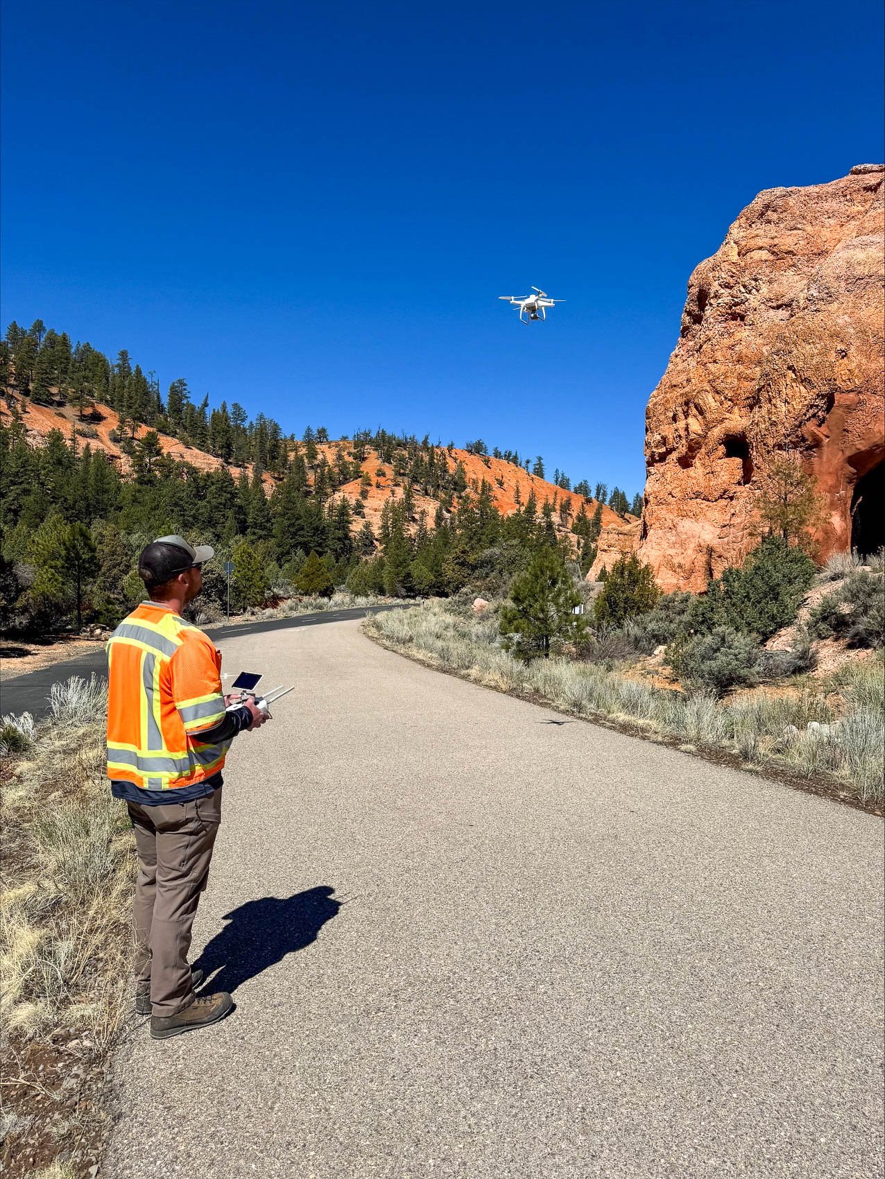
When it comes to safeguarding a century-old stone arch, UDOT has adopted a high-tech strategy involving drones and LiDAR technology, which pairs cutting-edge robotics with precision laser scanning:
Why Drones?
- Efficiency and Safety: Drones can rapidly and safely navigate treacherous terrains to collect data, eliminating the dangers posed to human inspectors.
- Precision: By gathering numerous high-resolution images, drones create detailed 3D models through photogrammetry, allowing experts to study and interact with the arches virtually from anywhere.
- Proactivity: Regular drone missions help detect issues early, ensuring that maintenance isn’t delayed for manual checks or emergencies.
Why LiDAR?
LiDAR technology uses laser beams to detect minute modifications, meticulously tracking every crack and bulge across the arches over time. Once dependent on extensive teams and resources, these operations are now efficiently conducted via drones like the RiCOPTER-M, DJI Matrice 400, and Zenmuse, traversing Utah’s high deserts with scientific accuracy.
The Process:
- Initial Survey (2019): In the aftermath of the 2019 crash, UDOT commenced its initiative by deploying drones and ground-based LiDAR for a complete digital evaluation.
- Ongoing Monitoring: Continuous image and data collection supports a dynamic digital twin—an evolving, detailed 3D rendering of the arches.
- Analysis and Alerts: Engineers track shifts and stress indicators, addressing even the subtlest changes.
- Data-Driven Actions: Situated sensors relay current movement and stress data, pivotal for timely interventions.
- Tomorrow’s Technology (2025 and Beyond): Enhanced funding will allow for the installation of advanced sensors and replacing outdated hardware to enhance the system’s reach and reliability.
The Greater Implications: Preserving Heritage and Pioneering Future Tech
To UDOT’s dedicated team, these arches stand for more than geology—they represent enduring stories of the people who pass beneath. As expressed by UDOT Region Four Director Kirk Thornock, safeguarding these formations ensures tourists will continue to marvel at Utah’s majestic offerings sustainably.
The narrative extends to drone operators and tech fans as well. UDOT’s venture is a vivid demonstration of drones’ capacity beyond capturing scenic landscapes and emphasizes their utility in cultural preservation and public safety enhancements. Technologies once reserved for cinematic effects or space missions are now accessible, empowering drone pilots to explore and protect cultural sites as modern archaeologists and guardians.
By achieving proactive maintenance through innovative technology, drones prove invaluable, deterring costly repairs and potential disasters. For Utah’s citizens and visitors, these efforts not only ensure safer travel routes but also safeguard a direct connection to America’s natural legacy.
Beyond the Tech: The Human Element
Behind the screen analyses, UDOT’s drone operators and engineers form a dynamic team, blending technical skills and passion. Veterans in the engineering realm and certified drone pilots unite their expertise with the latest technology to preserve these landmarks.
The team participates in collaborative virtual sessions where geologists and tech experts analyze 3D models and strategize efficient responses. Their comprehensive training ensures they remain agile and effective, even when weather challenges or peak tourism hits require on-the-fly adjustments.
From rapid post-storm repairs to everyday monitoring, UDOT’s crew demonstrates that their dedication goes beyond mere duty—it’s about preserving the natural allure they love and proudly sharing their achievements as they continue to refine their approach and share their findings with academic and recreational audiences alike.
Planning for the Future: UDOT’s Preservation Vision
Phase Two Initiatives:
- New, hard-to-reach sensor installations facilitated by drones.
- Increased and automated flights, powered by state-of-the-art batteries and AI-driven flight path technology.
- Public access to collected data, offering educational opportunities to global geology enthusiasts eager to explore these stunning formations.
Years ahead, UDOT seeks to develop a comprehensive preservation playbook that can benefit sites worldwide, potentially improving practices in national parks and UNESCO sites. These ambitions include exploring fully autonomous drone operations and pioneering sensor and AI capabilities, ensuring early detection and preventive care.
Learning from UDOT’s Journey
From a technical enthusiast’s perspective, UDOT’s story reveals crucial insights:
- Drones have emerged as significant tools for sustainable environmental and cultural stewardship.
- Collaboration among technical innovators, community advocates, and policymakers fuels impactful outcomes.
- Proactive investment in technology surpasses reactive crisis interventions consistently.
Taking part is accessible: UDOT drone operators exemplify how training and creativity make significant contributions possible, encouraging public engagement in preserving local landmarks through model solutions inspired by UDOT’s groundbreaking work.
Charting a Path Forward: Utah’s Legacy of Innovation and Conservation
With vigilant care and technological prowess, Utah’s Red Canyon Arches remain a testament to the confluence of traditional conservation and modern technological frontier. Drone pilots, engineers, and anyone enthralled by grand scenery and innovation will find a piece of themselves in this remarkable narrative, where the act of flying secures access to our shared past—and opens new avenues for future engagement.
Should your drone find itself dusted with red sediment during exploration, consider it not just a challenge but a symbol of dedication to safeguarding history.