Drones Revolutionize Kīlauea’s Eruption Monitoring: How Aerial Tech is Transforming Volcanology
When the ground quakes and flames ascend from Hawai‘i’s core, Kīlauea reminds us of Earth’s dynamic energy. For centuries, volcanoes have fascinated us, but it’s the strides in drone technology—uncrewed aerial systems (UAS)—that are providing volcanologists with newfound capabilities. This article uncovers how drones transformed Kīlauea’s eruption monitoring, delivering safer, faster, and more comprehensive data to the experts who mediate between nature’s power and local communities.
1. Why Drones? The Kīlauea Challenge
Kīlauea ranks among the globe’s most active volcanoes, erupting frequently and without warning. For researchers, emergency teams, and residents, timely data distinguishes safety from disaster. Kīlauea’s eruptions generate hazardous lava flows, toxic fumes, and shifting terrain, making traditional ground-based monitoring risky and sometimes unfeasible.
Enter drones. Modern UAS can soar over molten lava, navigate debris-filled skies, and venture into hazardous craters, all while sending real-time data back to the scientists. This eliminates the need for hefty helicopters, dangerous fieldwork, or conjecture—just a skilled operator and a high-tech aerial fleet.
2. The Tech Behind the Transformation
Precision Mapping and Real-Time Data
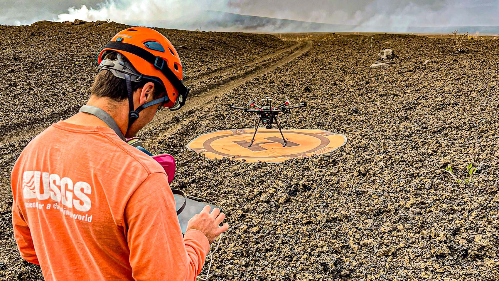
Since late 2024, the summit of Kīlauea has experienced 27 eruption episodes, including dramatic lava fountains reaching heights of 1,250 feet. On June 26, 2025, USGS (U.S. Geological Survey) teams deployed drones over Halema‘uma‘u crater to capture detailed maps of lava flows and tephra deposits. These maps revealed up to 80 feet of new lava blanketing parts of the crater, reshaping the landscape significantly.
How do they accomplish this?
- High-resolution imaging: Drones like the DJI Matrice 600, equipped with advanced thermal and visual cameras, fly close to vents and ponds, capturing intricate details such as surface temperatures, gas plumes, and lava movements that are unattainable from the ground.
- Thermal mapping: Thermal cameras (e.g., Zenmuse XT2) record heat signatures, identifying active lava channels and hidden hot spots.
- 3D terrain models: By overlapping hundreds of drone images, researchers create accurate 3D models to monitor landscape changes almost instantaneously.
Safer Science and Smarter Decisions
- Reduced risky fieldwork: Drones minimize the necessity for scientists to approach unstable craters, significantly lowering injury or death risks.
- Night and adverse-weather capabilities: Unlike manned aircraft, drones can operate at night or through thick ash when conditions are too perilous for people or helicopters, providing continuous monitoring of the eruption.
- AI Assistance: Advanced AI algorithms process the constant flow of drone data to identify patterns indicating potential eruptions or changes in hazards, offering pre-emptive protection.
3. From Theory to Action: Drones on the Frontlines
Critical Situational Awareness for First Responders
During eruptions, like those occurring in 2018 and the current series, drones have been crucial for emergency management:
- Evacuation mapping: Hourly drone flyovers provided up-to-date maps of lava paths, ensuring residents and responders knew the safest escape routes.
- Hazard detection: Drones relayed live videos of advancing lava, allowing emergency centers to track flows threatening homes or infrastructure, including a geothermal plant housing potentially dangerous materials.
- Rescue missions: In one instance, a USGS drone identified a resident dangerously near a lava flow, facilitating a timely rescue.
Innovative Science in Action: The Rose Hart Case Study
During the 2018 eruption, graduate student Rose Hart spearheaded drone operations, conducting daily missions across ash-covered skies. Her team’s hourly images of lava paths, integrated into GIS platforms, were vital in predicting dangers and organizing evacuations. Their efforts received international acclaim and established a benchmark for scientific drone use.
4. The Data Revolution: What We’re Learning About Kīlauea
Unprecedented Insights
- Lava pond cycles: Drone-equipped thermal cameras documented “gas pistoning,” where a lava pond quietly rises before rapidly collapsing as volcanic gases are released.
- Tephra mapping: Drones surveyed thick deposits of volcanic ash and rock, sometimes obstructing roads like Crater Rim Drive under a foot of debris, aiding authorities in hazard assessment and response planning.
- Eruption forecasting: By integrating drone data with satellite imagery and AI analysis, researchers now better predict potential eruption escalations—improving warnings and safeguarding lives.
Statistical Impact
- Over 27 major eruption episodes have been mapped since December 2024 using drone flights.
- Up to 80 feet of new lava were measured in certain parts of Halema‘uma‘u crater.
- Hourly mapping facilitated evacuation planning that protected entire communities in 2018.
5. The Human Touch: People Behind the Drones
These advancements are spearheaded by passionate scientists and drone pilots:
- HVO Geologists: The dedicated teams at USGS Hawaiian Volcano Observatory are leaders in operational drone volcanology.
- Young Innovators: Students like Rose Hart are pioneering paths, fusing academic research with real-world crisis management.
- Disaster Robotics Experts: Researchers like Dr. Murphy lead teams deploying drones for disaster mapping and search-and-rescue, contributing to global best practices.
Despite the technology, their commitment to safety, curiosity, and community remains central to their mission.
6. Business and Policy: Lessons for Drone Advocates
Legal and Regulatory Frontlines
- Permits and permissions: All USGS drone operations are conducted with special authorization within protected areas, as unauthorized drone use is prohibited under federal law.
- Operational best practices: Emergency teams discovered that targeted drone missions are more effective for decision-makers—a practice now shared globally.
Emerging Commercial Applications
- Private-sector opportunities: Kīlauea exemplifies how drones can assist with insurance, infrastructure inspection, environmental monitoring, and even drone delivery in hazardous or remote locations.
- Public trust: The success of these missions builds community confidence in drone technology as a beneficial tool, not merely for recreation or surveillance.
7. The Future: What’s Next for Drones and Volcanology?
The drone revolution is only beginning:
- AI and Machine Learning: Automating the detection of eruption warning signs to offer even quicker alerts.
- Swarm drones: Coordinated groups can offer simultaneous, multi-angle monitoring of eruptions and hazards.
- Integration with satellites: “Smart” fusion of live drone feeds with satellite data can enable perpetual, all-weather, global volcano monitoring.
Soon, we might even see cinematic VR tours of erupting volcanoes, allowing everyone to safely witness the spectacle from their homes.
8. Final Words: Drones, Humans, and the Fiery Earth
Standing at a crater’s edge, observing flowing lava and swirling sulfur clouds, it’s humbling to witness nature’s raw power. However, thanks to drones, we’re more than spectators—we’re active participants in discovery. Once science fiction, these tools are now key allies in safeguarding lives and unveiling volcanic mysteries.
So next time you see imagery of Kīlauea’s glowing summit on the news, remember: behind the camera is a skilled aviator, a renowned geologist, and a drone, all working at the forefront of human curiosity.
The timeless roar of the volcano continues, but our way of listening has never been more advanced.
Quick Tips for Drone Enthusiasts and Professionals:
- Looking to buy a drone for scientific or emergency use? Invest in models that are durable and resistant to weather, with high-resolution cameras. The DJI Matrice 600 and Zenmuse XT2 combination is proven in action at Kīlauea.
- Planning to operate drones near protected areas? Obtain the necessary permissions and collaborate with local authorities—legal compliance is essential.
- Interested in a career in drone volcanology? Study fields like geology, robotics, or GIS, and engage with research projects or disaster response teams. Field experience is invaluable.
- Want to watch drone footage? Check resources from the USGS and educational institutions for inspiration and educational content.
Kīlauea is evolving—and drones are helping us keep up. Whether you’re a scientist, a first responder, or a tech enthusiast, the drone revolution is charting a safer, smarter course through Earth’s volatile frontiers.