New Upgrade Packages for MALÅ Ground Explorer and GeoDrone 80: Everything Professionals Need to Know
In the competitive realm of geophysical surveying, progress is about pushing boundaries—sometimes, quite literally. The latest upgrade packages for the celebrated MALÅ Ground Explorer and the airborne GeoDrone 80 promise a remarkable enhancement in ground-penetrating radar (GPR) technology, captivating engineers, geologists, and surveyors. Here’s a comprehensive look into the significant changes, their impact, and how they can revolutionize your work.
Why the Buzz? The Next Level of GPR
Favored for their durability and depth penetration, the MALÅ Ground Explorer (GX) and GeoDrone 80 antennas are widely recognized. However, with technology’s fast pace, the demand for more efficient, precise, and multifaceted tools grows.
Guideline Geo’s recent upgrade packages provide enhancements tailored to improve efficiency, data quality, and operational flexibility for any MALÅ antenna that supports apps. Think of these upgrades as infusing new life into your existing tools.
What’s New? Key Features of the Upgrade Packages
Optimized Battery Handling
- Extend your survey sessions without increasing battery usage, allowing more time for data collection by minimizing the interruptions caused by switching batteries or power concerns, especially valuable for drone operations at large or hazardous locations.
PPS (Pulse Per Second) Support
- By integrating accurate time-synchronization with external GPS, this improvement heightens positioning accuracy, critical for multi-sensor projects focused on spatial accuracy like geological profiling.
MALÅ Motion Trig
- This feature initiates data collection based on GPS movement, automating the process ideally suited for field teams using carts or drones where manual operation isn’t viable. It simplifies operations, reduces human errors, and ensures precise data collection.
Extended Time Window (for GX 80/160 & GD 80 Antennas)
- With increased time windows, the system records reflections from deeper layers, surpassing previous hardware limits. This is especially useful in areas like bathymetry, glaciology, and deep subsurface surveys, facilitating mapping and feature identification.
Imagine more accurate riverbed mapping, integrating deep-seated features for infrastructure—it’s all possible now.
Real-World Impact: Use Cases & Applications
Bathymetry Profiling
Mapping underwater topography such as riverbeds and shallow coastal areas is streamlined, aiding environmental studies and planning for infrastructure like bridges and pipelines.
Glaciology & Arctic Research
Essential for climate studies, these tools enable profiling of snow and ice layers, detection of crevasses, and monitoring of glacial changes.
Geological & Archaeological Mapping
From sinkhole detection to imaging bedrock depths, the extended time window offers insights in difficult geological contexts.
Hazardous & Inaccessible Terrain
The GeoDrone 80 makes sample collection in hard-to-reach areas like avalanche-prone slopes feasible, ensuring high-quality GPR surveys.
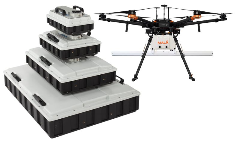
Meet the Machines: A Quick Technical Recap
| Feature | MALÅ Ground Explorer GX | MALÅ GeoDrone 80 |
|---|---|---|
| Main function | Ground-based GPR | Airborne GPR (drone mountable) |
| Core technology | HDR (High Dynamic Range) GPR | HDR GPR (80 MHz) |
| New upgrades unlock | Battery optimization, PPS, Motion Trig, Extended time window | Same as GX + airborne-specific gains |
| Battery life (post-upgrade) | Extended, varies by use | 3+ hours typical |
| Positioning | GPS, now with PPS support | Real-time DGPS (SBAS) + PPS support |
| Weight (GeoDrone 80 antenna) | – | 3.23kg incl. 2 batteries |
| Typical deployment | Cart, sled, vehicle | Any standard drone (>3.5kg lift) |
| Application focus | Geotechnical, environmental, utility | Hazardous, remote, or aquatic sites |
| Data processing | MALÅ Vision software suite | MALÅ Vision (web/desktop) |
How to Upgrade: The Practical Stuff
Simple upgrade process: Send your antennas for factory-installed upgrades; receive them back with new firmware and features.
Available: For current app-enabled MALÅ Ground Explorer and GeoDrone 80 units. For compatibility queries, customer support is available for free consultations.
Why Upgrade? The Business Case
Greater Productivity
Minimized downtime and extended field sessions mean an uptick in project completion and revenue.
Unlock New Revenue Streams
Enhanced penetration and airborne capabilities enable specialized projects, from glacial studies to underwater mapping.
Higher Data Quality
Precise data translates to improved client reports and a better market reputation.
Competitive Differentiation
With cutting-edge technology, you can secure projects and stand out from competitors.
The Human Side: Who’s Behind MALÅ?
Guideline Geo, the parent company of MALÅ, has spearheaded innovation in near-surface geotechnology since 1923. Known for comprehensive support and innovation, their experts are partners in solving real-world problems.
Frequently Asked Questions
Q: Is drone use with GeoDrone 80 legal worldwide? Flight regulations vary; check local laws before using drones for surveys. Always comply with national regulatory standards.
Q: Is the upgrade beneficial for small businesses? The upgrades offer substantial returns on investment, especially for small consultancies aiming to access premium features.
Q: Can students access the upgrades? Educational programs widely use MALÅ systems, and upgrades enhance the safety and data quality of student projects.
Closing Thought
Whether you’re unveiling ancient riverbeds or charting icy terrains, the upgraded MALÅ Ground Explorer and GeoDrone 80 are designed for deeper, smarter survey missions.