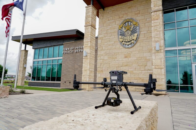
Prosper Police Department’s Drone-First Responder 2.0: Pioneering a New Era in Public Safety
In 2025, the Prosper Police Department in Texas became a trailblazer by deploying the innovative Flock Aerodome Drone as First Responder (DFR) 2.0 system. This advancement redefines modern public safety by seamlessly integrating sophisticated drone technology into their operations, effectively setting a new national standard for emergency response, crime prevention, and community trust.
Understanding Drone as First Responder 2.0
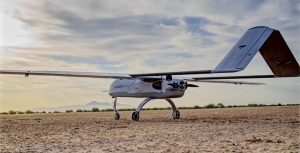
The Drone as First Responder 2.0 (DFR 2.0) marks the next stage of drone-assisted emergency service. Unlike its predecessor, which depended on manual operations and limited automation, DFR 2.0 offers an array of advanced features, including:
- Automated drone deployment and retrieval via “drone in a box” technology
- Battery-swapping docks distributed citywide for uninterrupted operation
- Detect and Avoid (DAA) radar for secure navigation in crowded airspace
- Integration with Flock911 dispatch and License Plate Readers (LPR)
- Remote piloting coupled with real-time data streaming
- Operations up to 400 feet in the air, akin to police helicopters, but at a substantially lower cost
This system dramatically enhances response times, with drones reaching incident locations in an average of just 86 seconds. This efficiency often surpasses that of traditional emergency vehicles and helicopters, offering immediate aerial surveillance at a significantly reduced operational cost.
Key Features and Innovations
1. Automated Patrol and Swift Response
Drones remain ready at automated battery-swapping stations throughout Prosper, launching quickly upon receiving a 911 call or emergency notification. Each deployment is remote-controlled by trained Prosper PD pilots, often arriving at scenes before human officers.
2. Advanced Detection & Airspace Management
Equipped with DAA radar, the system actively scans airspace for other aircraft. It facilitates BVLOS (Beyond Visual Line of Sight) operations, previously allowed only under strict FAA waivers, and can execute automatic evasive actions to avoid potential airspace conflicts.
3. Seamless Public Safety Integration
Linkages with Flock911 dispatch, license plate readers, and law enforcement databases enable drones to assist in tracking suspects, recovering stolen vehicles, and real-time crime deterrence through automated and pilot-controlled patrols led by FAA-certified officers.
4. Data Security & Transparency
All drone operations are documented and accessible via an online platform, fostering accountability and community trust. Flight data is encrypted and stored on secure, US-based servers, addressing both privacy and regulatory standards.
5. Operational Impact
Other departments utilizing DFR 2.0 have experienced:
- 71% average decrease in response times
- 89% increase in identification and recovery of suspects and stolen vehicles
- Resolution of 20% of incidents without needing a patrol unit
In the early weeks of use in Prosper, drones were pivotal in a felony traffic stop, recovering multiple stolen cars, and capturing a wanted person.
Real-Life Scenario: Drone-First Response in Action
On a regular day, Prosper dispatch receives word of a suspicious vehicle tied to a recent theft. A DFR 2.0 drone is launched within seconds from its closest dock, directed by a certified officer. Arriving in under two minutes, the drone relays high-resolution video to command, confirming the vehicle’s theft status via license plate recognition. Law enforcement is promptly dispatched with precise real-time data, leading to a swift and effective resolution before the suspect realizes they’re under surveillance.
Community Benefits
- Enhanced Safety: Drones provide early assessments of potentially dangerous scenarios, reducing risks for both the public and first responders.
- Rapid Response: With an average citywide response time of 86 seconds, Prosper PD ensures timely intervention.
- Proactive Law Enforcement: Automated patrols help deter crime through visible aerial observation and quick evidence gathering.
- Cost Efficiency: The cost of operating drones is significantly lower than maintaining helicopter fleets, allowing for better allocation of community resources.
- Privacy and Trust: Strong protocols, flight transparency, and public outreach build community confidence and ease privacy concerns.
Expert Opinions and Community Perspectives
Chief Doug Kowalski of Prosper PD: “These advanced drone programs provide a powerful tool for our officers, enhancing community safety and service. Their benefits parallel those of helicopters, improving our response capabilities significantly.”
Mayor David Bristol: “The Town Council is committed to investing in technology that boosts public safety and officer protection, reinforcing community well-being.”
Rahul Sidhu, VP of Aviation at Flock Safety: “Partnering with Prosper PD in deploying Texas’ first Flock Aerodome underlines our dedication to elevating public safety technology statewide.”
Funding, Collaboration, and Community Involvement
The DFR 2.0 initiative is partly financed by the Texas Motor Vehicle Crime Prevention Authority’s Auto Theft Reduction Grant, emphasizing the initiative’s financial prudence and innovation. Ongoing transparency is maintained through public sessions and press briefings, with plans for continued community engagement and feedback.
Technical Functionality of DFR 2.0
| Feature | Description |
|---|---|
| Drone Model | DJI-based drones with advanced obstacle sensing and RTK positioning |
| Deployment | Automated docking stations across the city (battery swap + charging) |
| Range & Precision | Operating radius up to 10 km, accuracy within ±3cm |
| Software | Live video/data streaming, address/GPS search, thermal imaging, geofencing |
| Operator Roles | Remote Operator (RO) and Remote Pilot in Command (RPIC) — enables both auto and manual ops |
| Data Integration | Connects with dispatch, LPR, and real-time alerts |
| Regulatory Compliance | FAA-aligned, public flight logs, geofencing, no-fly zones |
Overcoming Challenges
Privacy Concerns: Compliance with FAA guidelines, city policies, and transparent public dashboards builds resident trust and counters potential misuse.
Airspace Safety: DAA technology minimizes collision risks in busy metropolitan areas.
Cost Challenges: Grant funding and demonstrated cost savings make drones an accessible option for communities like Prosper.
Training & Expansion: DFR 2.0’s flexible staffing and scalable operations minimize the need for additional full-time personnel.
Human Element: Culture, Collaboration, and Success Stories
Prosper PD’s adoption of DFR 2.0 is driven not just by technology but by committed personnel and a supportive town council prioritizing innovation and transparency. Notable achievements include:
- Rapid location of missing persons using thermal imaging
- Crime prevention through visible aerial monitoring
- Improved safety during traffic stops and pursuits
The community feels increased security knowing their police are equipped with state-of-the-art tools while respecting privacy.
Future Directions: The Evolution of Public Safety
Prosper’s DFR 2.0 program serves as a model for others, proving valuable beyond traditional law enforcement roles, such as in accident scene documentation and search and rescue missions. Future enhancements may include AI integration, better data sharing, and more flexible airspace usage. As costs decrease and regulatory paths open, this technology could be widespread, enhancing safety and public confidence across more communities.
In summary, the Prosper Police Department’s deployment of Drone-First Responder 2.0 redefines public safety by integrating automation and transparency with community engagement. This pioneering effort has the potential to shape the next generation of law enforcement.