High-Altitude Aircraft Use NASA Sensors to Hunt for Minerals: Unveiling a New Era of Discovery from the Skies
In the realm of technological wonders, stories that intertwine advanced science, national strategy, and a hint of espionage are rare. Such is the high-flying quest by NASA to locate minerals buried deep beneath the Earth’s surface. Picture a sleek aircraft flying over the dry terrain of America, not as a spy but searching for elements crucial to our digital age—powering gadgets, electric cars, and windmills.
This scenario isn’t fiction, but rather the cutting edge of mineral exploration, fueled by NASA’s sophisticated sensors and a national agenda that seeks energy autonomy and technological independence.
1. Why the Hunt for Critical Minerals Has Gone Sky-High
Contemporary living hinges on a collection of rare minerals—lithium, cobalt, nickel, and rare earth elements—which are indispensable in everything from EV batteries to aerospace engineering. Many are deemed “critical” as their supply disruptions could destabilize economies and national security systems. Historically reliant on foreign sources, the U.S. now sees a pressing need to unearth domestic mineral wealth.
This ambition drives the GEMx—Geological Earth Mapping Experiment—an effort helmed by NASA and the U.S. Geological Survey (USGS). Their mission: to uncover and chart deposits of critical minerals across the vast, stark, and underexplored landscapes of the American West.
2. Meet the High-Flying Heroes: NASA’s ER-2 and Next-Level Sensors
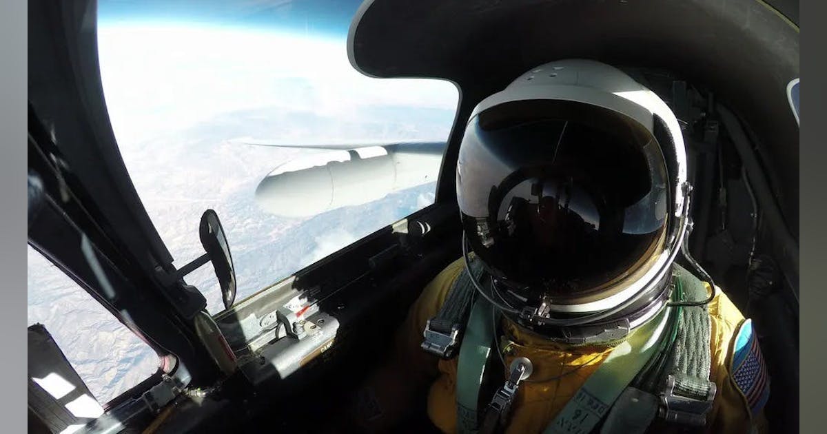
The pivotal element in this aerial revolution is the NASA ER-2 research aircraft—a high-altitude marvel derived from the legendary U-2 spy plane recognized in Cold War tales. Yet, unlike its espionage forbearers, the ER-2’s mission is all about clarity: unveiling the hidden geological story of the American Southwest.
Essential Technology on Board:
- AVIRIS (Airborne Visible/Infrared Imaging Spectrometer): This sensor captures hundreds of wavelengths, far exceeding human visual capacity, enabling detection of the mineral “fingerprints” on Earth’s crust.
- MASTER (MODIS/ASTER Airborne Simulator): Concentrates on thermal infrared findings, offering added insights, especially for not-so-visibly accessible minerals.
- EMIT (Earth Surface Mineral Dust Source Investigation, on the ISS): Though not aboard the ER-2, EMIT supplies supplemental global data from its station on the International Space Station.
Fun fact: To operate at 65,000 feet—nearly double commercial airliner altitude—the pilot wears a specialized suit akin to an astronaut’s, allowing endurance and workability in near-space environments.
3. How Do NASA’s Sensors Find Minerals? It’s All About Light
NASA’s unique tactic, beyond its pilots with unshakeable resolve, is imaging spectroscopy. By scrutinizing sunlight reflected off rocks and soil, sensors can decipher the characteristic spectral signature of various minerals. This is akin to a cosmic barcode scanner determining the ground’s molecular makeup, uncovering hidden deposits unknown even to seasoned geologists.
Hyperspectral imaging is not only fascinating but groundbreaking. It allows the differentiation between lithium-bearing clays and standard mudstone or between valuable rare earth minerals and plain dirt.
Thermal and infrared bands enhance the picture, indicating geophysical features that traditional tools might overlook.
4. Where and What are They Surveying?
Primary focus areas include the dry stretches of California, Nevada, Arizona, Oregon, and New Mexico—regions previously known for minerals yet insufficiently mapped by modern technology.
- The GEMx project’s survey scope rivals the size of Spain, covering astounding distances with every excursion.
- The terrain, seemingly dull and brown to the naked eye, transforms into vivid arrays of kaleidoscope minerals through NASA’s lens.
5. Why Does This Matter?
For American Industry & National Security:
- Reduced foreign reliance: By locating feasible domestic sources of key minerals, the U.S. can bolster its supply chains for clean energy technologies, defense, and electronics.
- Strategic autonomy: Identifying extractable critical minerals domestically could lessen dependence on foreign supplies, states Kevin Reath, NASA’s deputy program manager for GEMx.
- Clean energy future: Materials like lithium and rare earths are vital for essential technologies like batteries, turbines, and solar panels.
For Science and Environment:
- Discovering “new” old mines: Sites previously dismissed as nonviable may hold untapped value; NASA’s technologies redraw the map.
- Climate research: Instruments like EMIT, primarily designed to understand mineral dust’s climate impact, provide invaluable data for mineral exploration.
6. The Power of Partnership: NASA, USGS, Industry, and Beyond
The GEMx initiative is a stellar example of collaboration, combining the resources of federal entities, state geologists, academia, and private firms. This open-data strategy ensures that findings not only aid national security but also empower local communities, miners, environmental advocates, and future innovators.
Example:
- Flight maps and data sets are being shared with geologists and companies, speeding up terrestrial exploration that traditionally took years using conventional prospecting methods.
7. Stories from the Field: Discoveries, Surprises, and Hope
- Revitalizing ghost towns: Locations deserted since the Gold Rush might thrive again for minerals fueling AI, wind energy, and electric vehicles.
- A patchwork of potential: Each survey reveals new “hotspots” with elements like cobalt and lithium, composing a fabric of unfolding opportunity.
- The human element: Pilots, engineers, and scientists work in concert, often analyzing real-time data in the hangar, which will frame the next era of U.S. industry.
8. Challenges and Limitations
- Not a magic solution: While these scanners can pinpoint mineral locations, further steps like drilling and sampling are needed to determine quantity and extraction feasibility.
- Environmental and policy barriers: Identifying minerals is just the start; issues like permits, land rights, and ecological reviews follow suit.
- The data influx: As sensors become more advanced, the task of data management, analysis, and storage grows more technical and demanding.
9. Pop Culture and a Dash of Humor: Sky Spies Turned Treasure Hunters
If this scenario resembles a spy movie, it’s not far from reality. The ER-2 calls to mind the drama of “Bridge of Spies” and “Call of Duty,” but rather than monitoring adversaries, they search for “digital-era treasures” buried beneath mountains of rock.
Adventures on these high-altitude missions include surprising turbulence at 65,000 feet and occasional technical glitches (insert dramatic Hollywood score), constantly teasing the mystery within the data awaiting revelation.
10. What Comes Next? The Future of Aerial Mineral Mapping
- Broadening the scope: As results come in, similar surveys might be conducted in other U.S. locales and globally in resource-rich but less-charted nations.
- Advances in sensors, improved insights: Ongoing improvements in sensor technology, AI-powered analytics, and compact satellites promise heightened precision and reach in the future.
- Overlap with climate science: The technologies identifying mineral wealth also unearth new details on how dust impacts global weather—a double scientific win.
11. How It All Adds Up: From Satellites to Smartphone Chips
Spanning from the International Space Station to the extended wings of the ER-2, NASA’s mission to map America’s vital minerals blends high-level science with strategic forecasting and pioneering spirit. This venture represents a modern-day “gold rush,” propelled not by pickaxes but by photons and hyperspectral imagery.
This effort extends beyond unearthing stones to laying the groundwork for a sustainable, secure, and inventive future.
“We’ve been exploring the earth beneath our feet for hundreds of years, and we’re discovering that we’ve only just begun.” — Kevin Reath, NASA
As NASA’s high-altitude “treasure seekers” pen a new chapter in exploration—melding advanced technology with timeless resourcefulness—the terrain below undergoes a transformative narrative.
For Enthusiasts and Innovators
If this account stirs your inner adventurer, stay tuned to NASA’s latest announcements—public gem discoveries from the GEMx surveys are emerging, inviting students, startups, and more to delve into America’s covert mineral riches.
Welcome to an era where the following significant discovery might be just underfoot, spotted first from the brink of space.
