DJI Terra 5.0 Update: Revolutionizing Drone Mapping with Photorealistic 3D Gaussian Splatting
If drone-based mapping is your field, you’ve likely heard about the latest buzz: DJI Terra 5.0 has arrived, introducing the pioneering photorealistic 3D Gaussian Splatting. This update is making waves in the industry, but why is it so critical for drone professionals and enthusiasts alike? In this guide, we’ll delve into the technology behind this innovation, examine its real-world applications, and offer expert tips to harness this groundbreaking mapping upgrade.
1. What is Gaussian Splatting?
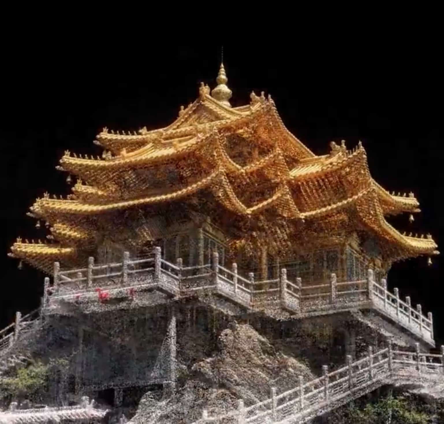
Essentially, Gaussian Splatting is an innovative method for rendering 3D spaces. Moving away from standard point clouds or polygon meshes, this technique reconstructs realistic virtual scenes by overlaying numerous semi-transparent ‘splats’ (or 3D Gaussian functions). Each splat encodes color and spatial data, merging seamlessly to create smooth, continuous surfaces. Think of this as pointillism adapting to the 3D digital realm.
Imagine crafting a landscape with color dots: layer them sufficiently, and the picture becomes lifelike. Gaussian Splatting follows the same principle—driven by advanced algorithms and aerial images.
Key Advantages:
- Photorealism: Enhances detail with strikingly lifelike models.
- Speed: Generates 3D models significantly quicker than traditional mesh pipelines, with tests showing up to twice the speed for large city data sets.
- Efficiency: Lightweight files facilitate sharing, real-time navigation, and seamless cloud collaboration.
- Completeness: Reduces common point cloud artefacts, resulting in more visually impactful reconstructions.
2. Why Is This Update a Game-Changer for DJI Terra Users?
With the 5.0 update, DJI Terra positions itself as the first major commercial drone mapping platform to natively incorporate photorealistic 3D Gaussian Splatting, thus redefining drone mapping:
- Real-time, High-Precision Modeling: The new 3DGS engine delivers detailed site models at twice the speed of traditional workflows, handling up to 30,000 images efficiently.
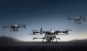
- Advanced Data Compatibility: From the enterprise-grade DJI Matrice series with Zenmuse L2/P1 sensors to consumer models like the Air 3 or Mavic 3 Pro, DJI drones are equipped to process data using this enhanced modeling approach.
- Integrated, Secure Workflow: The Terra suite boasts an end-to-end acquisition-to-analysis ecosystem, with cluster processing easing large-scale survey tasks with added security and speed.
3. How Does Gaussian Splatting Work in the DJI Terra Workflow?
Step-by-step overview:
- Flight Planning: Utilize Terra’s mission tools for automated flights, ensuring optimal photo coverage for precise reconstruction.
- Image Acquisition: Capture from dozens to thousands of photos using a DJI drone. The new process supports RGB and multispectral images and LiDAR data.
- Data Import: Import images or laser scans into Terra’s desktop client.
- Aerotriangulation: Terra automatically calibrates camera positions and angles for accurate georeferencing.
- 3D Model Generation: Select Gaussian Splatting as the method, and Terra will convert images into photorealistic models rapidly.
- Export & Share: Download or share models with stakeholders—even those lacking specialist 3D viewers.
4. Real-World Benefits for Professionals and Enterprises
For Surveyors & Civil Engineers:
- Attain centimeter-level accuracy for construction sites or infrastructure inspections, minimizing site visits and rework.
- Create digital twins to facilitate planning and compliance.
For Construction & Urban Planning:
- Oversee project advances with frequent, photorealistic 3D progress updates.
- Preempt site issues before they incur costly delays.
For Cultural Heritage & Preservation:
- Develop immersive digital replicas of historical sites, safeguarding details under diverse conditions.
For Agriculture & Environmental Monitoring:
- Integrate multispectral insights with realistic 3D views to guide farming strategies, assess crop health, and manage terrains.
Case Study: City Block Modeling
A survey crew mapped an entire urban block via DJI Matrice 350 and Zenmuse L2. Conventional mesh methods took 12 hours on robust hardware, but with Gaussian Splatting under Terra 5.0, the task completed in less than six hours, producing visually superior, compact files.
5. Side-by-Side: Point Clouds vs. Gaussian Splatting
| Feature | Point Cloud | Gaussian Splatting |
|---|---|---|
| Visual Realism | Medium | High (photorealistic) |
| File Size | Large | Compact |
| Processing Time | High | Low |
| Shareability | Limited (platform specifics) | Effortless, web-enabled |
| Hardware Friendliness | Resource-demanding | Operable on modest GPUs |
| Artifact Handling | Susceptible to gaps and noise | Smooth, continuous |
| Best Suited For | Detailed measurements and analysis | Visualization, digital twins, stakeholder engagement |
6. Getting Started: Hardware, Software, and Best Practices
Is My Drone Compatible?
- Enterprise Users: DJI Matrice 350/300/400 with Zenmuse L2 or P1 excels in photogrammetry and LiDAR.
- Prosumer/Consumer: Mavic 3 Pro, Air 3, and Mini 4 Pro are suited for small-to-medium locales like gardens and rooftops.
- Minimum Specs: Terra 5.0’s Gaussian Splatting engine initiates on 4GB VRAM, with larger jobs favoring a modern GPU (8–24GB VRAM).
Tip: For vast city-scale projects, employ DJI Terra’s new cluster processing to distribute tasks across machines, avoiding bottlenecks.
Licensing & Data Security:
- Terra is a licensed solution; ensure subscriptions are current for complete 3DGS access.
- For sensitive locations, work offline—Terra’s local processes secure data integrity and client privacy.
7. Pro Tips for Stunning Results
- Ensure uniform overlap and lighting during flight—avoid abrupt shadows or glare.
- For utmost realism, integrate RGB and LiDAR data for hybrid reconstructions.
- Utilize Terra’s coordinate recommendations to align survey data with national standards.
- Segment photos into logical areas—smaller sets expedite completion and quality control.
- Impress clients by sharing models via web links or light files, captivating even non-technical audiences.
8. Where Is the Industry Headed?
The introduction of Gaussian Splatting in DJI Terra 5.0 heralds a new era of affordable, proficient, and visually stunning 3D mapping. Industry experts anticipate applications beyond surveying, spanning real estate, immersive urban planning, smart farming, and even entertainment and AR.
As Billy Kyle, a renowned drone specialist, remarked, “3D modeling captivates me, and I am thrilled by advancements in the software stitching it all together.”
This sentiment echoes the industry’s enthusiasm: professionals have long weighed speed against realism, but with this update, compromise is unnecessary—Terra’s new approach delivers both.
9. Expert Team, Trusted Solution
At the core of these innovations is the DJI Terra team, a synergy of analytic rigor and creative foresight. Attuned to pilot insights, they enhance tools via real-world application, upholding security and reliability. Users drive these growths: from Berlin’s city planners designing transit, to Asian archaeologists digitally preserving UNESCO sites.
Our strategy: Expertise based on trust, authentic partnerships, and a pledge to keep leading-edge—one splat at a time.
10. Final Thoughts: Should You Upgrade Now? Absolutely.
For those serious about drone mapping, moving to photorealistic 3D Gaussian Splatting represents a giant leap. Whether you’re a data scientist seeking precision, a surveyor aiming for efficiency, or a digital artist craving realism, DJI Terra 5.0 sets the benchmark. Try it for your next project—and prepare to be impressed.
Keywords: DJI Terra 5.0, Gaussian Splatting, best drone for mapping, photorealistic 3D maps, drone modeling, digital twins, construction drone, surveying drone, 3DGS, mesh vs splatting, cluster processing, DJI Matrice, infrared mapping, drone mapping software, drone inspection, drone mapping accuracy.
If you have questions or wish to see real-world results before committing, reach out—our team is ready to unlock the art of the possible with you.