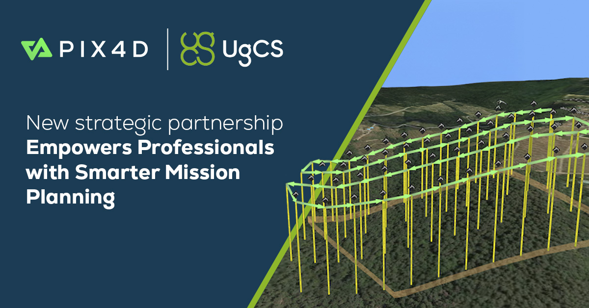
New Partnership Between Pix4D and UgCS: Revolutionizing Professional Drone Mission Planning
The drone industry is witnessing a wave of innovation with a newly announced collaboration between Pix4D, a leader in photogrammetry software, and SPH Engineering’s UgCS, a distinguished provider of sophisticated drone mission planning tools. This partnership aims to enhance the capabilities of professionals involved in drone mapping, surveying, LiDAR operations, infrastructure inspections, and other in-depth aerial projects.
What Does the Pix4D & UgCS Partnership Mean for Drone Professionals?
Imagine being tasked with mapping a power plant, surveying a complex mining site, or organizing photogrammetry tasks in areas without internet access. The necessity for tools that provide precision, adaptability, and reliability, free from complications or vendor dependency, becomes clear.
This collaboration brings together the comprehensive mission planning strength of UgCS with the superior photogrammetric processing capabilities of Pix4D. Here’s why this partnership is transformative:
- Full Mission Lifecycle Integration: Seamlessly transition from planning detailed drone routes in 3D to creating survey-grade maps and models, ensuring a streamlined and intelligent workflow across platforms.
- Support for Diverse Drone Fleets: UgCS accommodates not only mainstream models but also NDAA-compliant, enterprise, and custom-built drones, perfect for sensitive or regulated operations.
- Offline and On-Premises Capabilities: UgCS operates locally, unlike many cloud-only systems, which is vital for fieldwork in remote or data-sensitive environments.
- Superior Customization: Advanced 3D mission planning, LiDAR, and photogrammetry tools allow professionals to tailor flights to specific project needs, whether for simple surveys or intricate inspections.
The Partnership in Practice: Key Features & Benefits
1. Advanced 3D Mission Planning
UgCS enables mission planning beyond simple line plotting on a flat map. The software provides:
- True 3D environment for designing flight paths, crucial for navigating around obstacles, following terrain contours, and planning missions over expansive or complex sites.
- Automated terrain following using imported DEM/DSM data, which maintains consistent data quality and ensures safe operations over varying landscapes.
- Specialized Photogrammetry Tools: Set up grid, corridor, or oblique capture missions tailored to site-specific needs and optimize routes for efficient image capture.
2. Complex Assets & Vertical Infrastructure
For those surveying towers, dams, chimneys, or skyscrapers, the partnership offers:
- Tools like Circlegrammetry and vertical inspection automation, which ensure safe and precise flights near tall structures, minimizing distortion beyond typical grid mission capabilities.
3. LiDAR & Beyond
UgCS supports LiDAR missions, offering automatic IMU calibration, loop turns, and trajectory smoothing to protect valuable equipment and assure data accuracy. This is crucial for advanced topography, pipeline mapping, and archaeological exploration.
4. Scalability & Repeatability
- Plan once and repeat reliably. Missions can be easily duplicated, adjusted, and re-flown for continuous site monitoring, infrastructure upkeep, or regulatory assessments, enhancing efficiency and accuracy over time.
5. Diverse Compatibility
- Supports mainstream UAVs (like DJI), but is particularly beneficial for fleets using open protocols (such as Ardupilot, PX4) or enterprise-specific equipment, including NDAA-compliant models.
Real-World Example
Case Study: A geospatial company tasked with annual inspections of high-voltage transmission towers in mountainous areas uses UgCS for route planning that adjusts to terrain, navigates near-vertical surfaces, and captures detailed imagery. Pix4D processes this data into high-resolution 3D models and orthomosaics meeting regulatory requirements. The systems’ offline capabilities ensure uninterrupted workflows even without network connectivity.
Human Touch: What the Experts Say
Andrey Kleymenov, Pix4D CEO: “Partnering with UgCS enables us to offer users a comprehensive solution for elaborate flight planning, complementing our processing tools. This collaboration aligns with our goal to support professional users with top-notch technologies throughout the data lifecycle.”
Kristaps Brass, UgCS Product Owner: “We understand the needs of Pix4D users who want a dependable alternative to their current mission planner. UgCS is prepared to provide a robust, flexible solution backed by extensive experience in intricate drone operations and are delighted to offer specialized onboarding assistance to facilitate smooth transitions.”
Why This Partnership Matters Now
- Regulation and Compliance: As global drone regulations tighten, compliance with NDAA requirements and data control is increasingly critical for professionals.
- Enterprise-Scale Demands: Organizations operating large fleets internationally need standardized, adaptable tools for diverse environments.
- Field-First Workflows: UgCS’s local data management and offline capabilities prevent interruptions, essential for remote or emergency operations.
The User Journey: From Planning to Analysis
Let’s explore a typical workflow empowered by this partnership:
- Mission Planning (UgCS): Design 3D flight paths, import boundaries, overlay previous images, and optimize routes considering terrain and obstacles.
- Data Acquisition: Execute automated flights with built-in safety checks, even in network-free zones.
- Data Processing (Pix4D): Process gathered imagery and point clouds to create detailed orthomosaics, 3D models, and advanced photogrammetric products.
- Analysis & Repeat Missions: Compare with past data to identify changes, and repeat or update missions as needed.
Key Advantages for Professional Users
- Reduced Risk: Incorporate advanced terrain and obstacle avoidance, with the ability to simulate missions in 3D.
- Improved Data Quality: Precision in mission settings, optimizing image overlap and exclusive inspection modes.
- Cost Efficiency: Streamline planning processes for long-term projects.
- Cross-Platform Freedom: Choose hardware and software that fit your strategy without constraints.
- Smooth Migration Support: Exclusive onboarding by the companies aids transition from other tools.
Who Does This Help Most?
- Surveying and mapping companies seeking precision and compliance.
- Infrastructure and utilities firms requiring routine surveys.
- Academic and research bodies seeking versatile, hardware-compatible operations.
- Government and public safety departments with offline, secure data needs.
- Innovative users: From drone racing enthusiasts to students, this ecosystem offers valuable tools.
How to Get Started
Pix4D and UgCS are committed to facilitating a seamless transition, offering:
- Special promotions and onboarding support for Pix4D users adopting UgCS.
- Regular updates, expert assistance, and extensive documentation.
- Active user forums and professional training ensure consistent support.
Final Thoughts and a Dash of Humor
Drones have evolved into versatile tools: imagination (and local restrictions) is the only limit. With the Pix4D and UgCS alliance, you’re gathering data like a pro, armed with the effectiveness of a Formula-1 pit crew and the precision of a Swiss craftsman.
Ever felt like your drone’s app treated you like a novice, sending you in circles or leaving you stranded? This partnership offers a smarter, smoother path to achieving your mission goals.
Ready to unlock a new age of aerial intelligence? The sky is not the limit—it’s just the start.
*Note to readers: For official guidance, training, and partnership offers, please visit the Pix4D and UgCS websites or contact their support teams.*