Unveiling the Future: The Q6V2 GEO UAV from ideaForge
The introduction of ideaForge’s Q6V2 GEO UAV represents a pivotal advancement in geospatial intelligence, offering a cutting-edge, survey-grade drone capable of mapping a wide range of terrains globally. This guide dives into the innovation and implications of the Q6V2 GEO, highlighting its growing influence across multiple sectors.
The Big Picture: Understanding the Importance of the Q6V2 GEO UAV
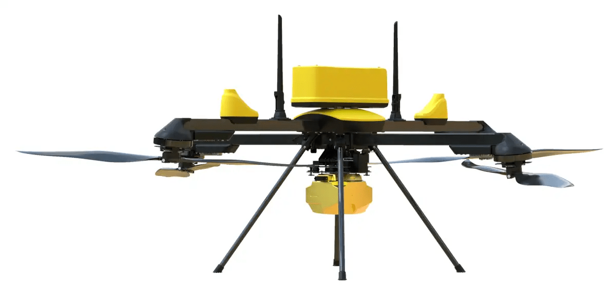
Picture a drone capable of meticulously mapping Himalayan glaciers during the chill of winter, generating a 3D digital model of a dynamic cityscape, and delving into dense forests for environmental studies. This is not a scene from a sci-fi saga, but the reality of ideaForge’s groundbreaking Q6V2 GEO UAV.
Constructed with a forward-thinking, modular build, this UAV supports swift sensor exchanges and withstands extreme temperatures. It transcends hobbyist interest, serving as an essential tool for governments, scientists, utility providers, and security forces in need of unrestricted, actionable geospatial information.
Distinctive Features: What Makes the Q6V2 GEO Stand Out?
- Extreme All-Terrain Capability: Designed to endure the challenges of sub-zero Himalayan climates, urban heat, and everything between, this UAV operates reliably from -30°C to +50°C.
- Endurance and Payload:
- Flight Time: Offers over 50 minutes of flight with LiDAR payload, crucial for prolonged mapping tasks.
- Take-off Weight: Under 7 kg, ensuring regulatory compliance and easy transportation.
- Survey-Grade Precision: Advanced IMU and PPK-enabled geotagging with seamless CORS integration deliver centimeter-level data accuracy.
- Enhanced Modularity:
- Accommodates up to five payloads, compatible with modular and third-party sensors for quick field configuration.
- Sensor Choices: High-resolution photogrammetry with the new 61MP AI-powered SHODHAM M61, LiDAR, oblique imaging, hyperspectral, thermal, and more future payloads.
- AI & Automation: The SHODHAM M61 uses machine learning for real-time data conversion into actionable insights.
- Field Proven: Over 2,000 successful missions conducted before public availability, with zero reported failures.
- Plug & Play Expansion: A flexible tech stack ensures durability and readiness for future upgrades, preserving investment value.
Application Scenarios: Who Benefits from the Q6V2 GEO?
Urban Planning & Infrastructure
- 3D city modeling for smart city initiatives, monitoring changes in construction, roadways, and utilities.
- Infrastructure audits, documenting digital records for structures like bridges and public transportation.
Mining & Resource Management
- Automated volume measurements in open-pit mining, aiding compliance reporting.
- Real-time vegetation risk assessment and terrain analysis to balance production efficiency with environmental safety.
Environmental Science & Forestry
- Monitoring glacier retreat and analyzing snow mass and water resources in climate impact studies.
- Utilizing LiDAR in dense forests for biomass and biodiversity research—previously challenging with other UAVs.
Defense & Security
- Reconnaissance and perimeter monitoring in rugged, GPS-limited, or high-risk zones—vital for global defense agencies.
- Communication relay and rescue operations in disaster-stricken areas.
Utilities & Critical Infrastructure
- Inspecting grids and towers, managing vegetation, and mapping infrastructure risks—minimizing outages and improving public safety.
The Internals of Q6V2 GEO’s Technology
| Feature | Q6V2 GEO Highlights | Significance |
|---|---|---|
| Flight Time | 50+ minutes (LiDAR payload) | Enables larger area mapping per flight |
| Take-off Weight | ≤ 7 kg | Lighter, facilitating easier regulatory approval |
| Payload Capacity | Modular: up to 5 payloads | Sensors can be swapped according to mission needs |
| Sensor Types | Photogrammetry, LiDAR, Oblique, Hyperspectral, Thermal | Supports industrial, scientific, and emergency operations |
| Temperature Tolerance | -30°C to +50°C | Offers flexibility across all fields and seasons |
| Accuracy | Survey grade: advanced IMU, PPK, CORS | Provides centimeter-level georeferencing |
| AI/ML Capability | SHODHAM M61 payload, onboard analytics | Delivers real-time intelligence, reducing data latency |
| Field History | 2,000+ missions pre-launch | Proven reliability |
Industry Impact: The Global Attention on This Launch
- GEOINT Market Transformation: The Q6V2 GEO is set to revolutionize the rapidly growing geospatial intelligence sector, where there’s a surging demand for dependable, high-resolution real-time data for both military and civilian purposes.
- Competing Globally: From spearheading digital strides within Indian defense, ideaForge now competes on an international scale, challenging major players like DJI and Autel with a UAV designed for the toughest global challenges.
- AI-Powered Decisions: Equips teams to transform large volumes of raw data into contextual, decision-ready intelligence promptly.
- Flexibility and Longevity: Its versatile, upgradeable design ensures clients’ operations evolve with changing aerial sciences or regulations, enhancing long-term investment benefits.
Expert Insights & Success Narratives
Ankit Mehta, CEO of ideaForge:
“The Q6V2 GEO and our geospatial tech stack push geospatial intelligence boundaries. We empower users to operate seamlessly in harsh terrains and climates. This platform unlocks possibilities from glaciers to urban corridors with precision.”
User Case #1: Glacier Research in the Himalayas
A climate research team successfully mapped a retreating glacier in -20°C conditions. “Previous drones struggled with battery life at such altitudes; however, the Q6V2 GEO completed the task flawlessly,” noted the project leader.
User Case #2: Urban Development Initiative
Using the 61 MP AI payload, an urban municipality crafted a live 3D city model, identifying numerous infrastructure issues beforehand, saving over $1 million in early repairs within the first year.
Why Q6V2 GEO is the Choice for Clients
- Exceptional Flexibility: Modular payload allows for varied missions without downtime.
- Beyond Precision: Enables highly accurate mine pit mapping and expansive resource surveys.
- Field-Tested Reliability: Highly reputed in defense and government missions due to proven dependability.
- Prepared for Unknowns: Boasts AI capabilities and all-weather readiness for missions beyond imagination.
Competitive Analysis
Where competitors falter in challenging climates, endurance, or data turnover times, the Q6V2 GEO excels with modularity, robustness, and analytics emphasis. It offers customizable payloads and automation, advancing beyond static-configuration rivals and negating expensive hardware swaps for new missions.
The Road Ahead for Geospatial Intelligence
The unveiling of the Q6V2 GEO heralds the dawn of unconstrained geospatial intelligence:
- Government authorities benefit from unmatched surveillance and mapping solutions.
- Industries address compliance, safety, and productivity with precise aerial analytics.
- Researchers access unprecedented spatial and temporal coverage, from polar studies to biodiversity corridors.
- Emergency teams deploy promptly with tailored sensors for life-saving operations.
In the air and at data centers, those who see further, map quicker, and adapt instantly gain the advantage. With the Q6V2 GEO, ideaForge sets a new benchmark in this frontier.
Final Thoughts: Beyond a Drone Company
ideaForge exemplifies more than mere drone manufacturing. Comprising engineers, field scientists, and ex-military analysts, they strive for geospatial intelligence democratization. Their PRAGYA 2025 summit, collaborative partnerships, and user-centric focus reflect a human, yet profoundly technical approach.
Whether shaping the trajectory of a business, community, or ecosystem, the lesson is clear: the right data transforms everything. And the Q6V2 GEO promises to deliver this transformative power where it’s most vital.