Drones Map Wildfire Risk: How BCIT and AI Are Transforming Firefighting in British Columbia
If you picture drones merely as advanced toys or cinematic tools, it’s time for a rethink. Imagine: a forest in British Columbia, bathed in sunlight, the crisp scent of pine. Above, a drone hums, mapping the terrain in astounding detail. This isn’t a casual flight—it’s the frontline of wildfire prevention, driven by advanced drones, artificial intelligence, and a commitment to safeguarding communities. Welcome to BCIT’s AI-driven approach to combating wildfires.
Why Wildfires in BC Matter to Everyone
Besides its stunning scenery and exceptional salmon burgers north of Seattle, British Columbia contends with some of Canada’s harshest wildfires. Climate change has extended fire seasons, leading to fires that consume vast areas, endanger communities, and challenge emergency services. In 2023, Canada allocated around $400 million for post-wildfire cleanup and recovery. But what if many of these disasters could be averted from the start?
Dr. Michal Aibin, BCIT Computing Program Head and a PhD expert in computer vision, believes drones and AI can transform wildfire management from a reactive to a proactive process. His research focuses on preventing fires before they ignite, not just responding once they’ve begun.
The Traditional Method: Helicopters, Satellites, and Hope
Wildfire prediction and management traditionally depend on:
- Aerial surveillance through helicopters and planes, which are costly, slow, and disruptive.
- Ground sensors that offer limited insights.
- Satellite imagery, which can be outdated or cloud-obscured at crucial times.
These methods, while necessary, are expensive and sometimes inaccurate, wasting valuable time.
The Impact of Drones: Powerful Yet Compact
Drones—formally known as Remotely Piloted Aircraft Systems (RPAS)—have shifted from hobbyist gadgets to essential tools in fire management, thanks to intelligent engineering and adept humans.
BCIT’s Drone Program Features
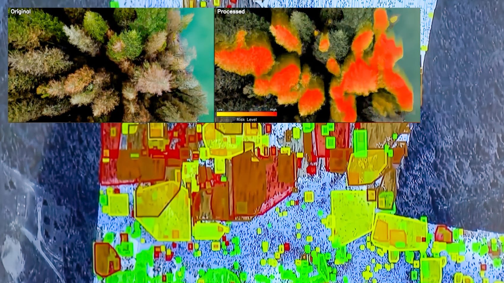
- High-Resolution Imaging: Drones capture detailed optical, thermal, and LiDAR images of forests, highlighting every element with clarity.
- Labeling and Mapping: AI-driven computer vision automatically analyzes images, identifying fire risks like dry brush, dead wood, and more.
- Frequent Updates: Unlike satellites, drones can operate under clouds and offer frequent data, crucial for real-world application.
- Actionable Maps: Resulting maps identify potential fire zones and vulnerable pathways, guiding preventive measures effectively.
AI Application: Computer Vision for Forests
Specializing in *computer vision*, Dr. Aibin’s work translates visual data into actionable insights. His algorithms mimic human arson detectors but with greater speed and no need for caffeine, distinguishing potential fire fuels from safe areas and recognizing changes that suggest increased flammability.
*“Instead of merely detecting fires or tallying burnt areas, we now anticipate potentially flammable zones and intervene days or weeks ahead,”* Dr. Aibin states.
The Cost of Prevention: Economic Benefits of Early Action
Consider these metrics illustrating the importance of early intervention:
- Canada dedicates approximately **$400 million annually** after wildfires.
- By reallocating just **10% of this budget** to drone and AI prevention, **30-40% of wildfires** could potentially be halted.
This strategic financial redirection saves landscapes, homes, and wildlife while alleviating pressure on emergency services.
From Data to Defense: The Operational Workflow
Understanding the process involves stages:
- Survey: Drones outfitted with cameras or LiDAR scan high-risk zones beneath dense canopies.
- Data Processing: AI analyzes extensive 3D datasets, pinpointing fuel, hazardous patterns, and risk areas.
- Home Ignition Zones: Areas categorized by fire risk guide municipalities to target preventive actions effectively.
- Vegetation Management: Teams implement targeted interventions based on updated digital maps.
- Follow-up Scans: Continuous drone operations update models, learning and adjusting to new conditions.
Using these maps, several BC communities have efficiently redirected resources, significantly lowering wildfire risks.
The Advantages of Drones and AI
BCIT’s approach offers distinct benefits over traditional methods:
- Precision: Identifying hidden risks undetected by conventional means.
- Speed: Drones swiftly scan vast terrains, with LiDAR penetrating dense tree canopies.
- Cost Efficiency: Reduces need for costly aerial methods and extensive personnel deployment.
- Climate Adaptability: Drones and AI models swiftly adjust to evolving weather patterns.
- Community Engagement: Provides crucial data to local authorities and residents lacking access to satellite resources.
Field Stories: Community Effects
Meet the team: It’s more than Dr. Aibin at work. BCIT’s initiative combines students, instructors, and partners like Spexi Geospatial, training future experts in drone piloting and disaster management.
A 2024 initiative in Kamloops analyzed a high-risk zone, unveiling dangerous dry fuels near residences. The city utilized drone data for effective outreach, reducing evacuation orders by 60% the following fire season.
Broad Technological Advancements: LiDAR and Beyond
While BCIT’s work shines in AI-supported computer vision, partners like Candrone advance with **LiDAR** and infrared sensor integrations. LiDAR drones create *3D models*, revealing risks even in difficult terrains, allowing detailed wildfire planning and response strategies.
Regulations and Challenges: Key Considerations
Drones used for wildfire surveillance in Canada must comply with rigorous regulations, including pilot certification and airspace rules. BCIT operates under permitted conditions, observing all related protocols.
Challenges remain:
- Weather Constraints: Drones have superior versatility but cannot fly under all conditions.
- Data Management: Managing extensive information requires advanced AI capabilities.
- Scaling Operations: Expanding from local forests to extensive regions relies on continuous software enhancement.
The Human Aspects: Why This Effort is Crucial
The standout feature at BCIT isn’t solely the technology, but the *people, dedication, and purpose* behind it.
Real impacts: Each created map prevents actual losses—preserving homes, educational facilities, and environmental corridors. Dr. Aibin and his team see tangible differences in community safety thanks to their work.
Advice and Insights for Drone Initiatives
– **Begin Small, but with Vision:** Even a localized mapping can incite community engagement.
– **Collaborate with Specialists:** Aligning with institutions or specialized companies enhances access to leading-edge technology.
– **Focus on Expertise:** Building operational and regulatory proficiency is essential, highlighting why BCIT’s educational programs are fundamental.
– **Secure Data Carefully:** Fire risk data impacts properties and insurance, demanding prudent handling.
– **Promote Human Narratives:** Successful projects gain trust by demonstrating protective impacts on real populations.
Future of Drone-Enhanced Firefighting
Globally, the drone and AI model, as advanced by BCIT, gains recognition, setting a precedent from California to Australia. Emerging trends involve:
- **Autonomous Fleets:** Self-deploying drones addressing threats promptly.
- **Integrated Dashboards:** Multi-tiered risk visualization tools for strategic field and governance decisions.
- **Citizen Participation:** Apps allowing inhabitants to comprehend and mitigate their fire risks.
- **Global Knowledge Exchange:** Sharing insights for worldwide fire hazard management, conserving resources and lives.
Why BCIT: Trusted Expertise
BCIT’s work is characterized by innovative research, cooperative governance, and genuine community interaction. The fusion of computer vision, drone mapping, and local cooperation illustrates a global model to adopt.
BCIT’s strength lies in motivated individuals—students, academics, and professionals—committed to ensuring safe communities, sustainable forests, and effective emergency services for the future.
Drones extend beyond simple selfies or cinematic mischief—they stand as necessary allies to our forests and towns. BCIT’s pioneering AI-assisted project showcases technology’s potential when partnered with local expertise and West Coast spirit, aiming to secure a safer future, flight by flight.