The Engineering Behind UgCS: Insights from Kristaps Brass on the Future of Drone Flight Planning
In the realm of digital aviation, few sectors are advancing as rapidly as drone flight planning. Central to this transformation is UgCS (Universal ground Control Software), crafted by SPH Engineering, under the leadership of visionary engineer and product owner Kristaps Brass. If you’re curious about why professionals across the globe choose UgCS for tasks ranging from LiDAR surveys over glaciers to mapping corridors within urban sprawl, continue reading for an in-depth exploration of the technology, team, and future prospects propelling this exceptional software.
Meet Kristaps Brass: The Human Mind Behind UgCS
Launching a complicated drone mission with UgCS involves the expertise of a worldwide team, anchored by Kristaps Brass, an engineer and product owner at SPH Engineering. Kristaps defies the typical “backroom coder” stereotype; he is a field-experienced engineer who has conducted customer training from Riga to Greenland’s glaciers and collaborated closely with clients and scientists in real-world projects.
“Having been with SPH Engineering since 2014, Kristaps has been involved in numerous field flight tests, leading customer training sessions globally (from Brazil to Australia), and even took part in a Greenland expedition in 2019 alongside Alexey Dobrovolskiy, CTO.”
Kristaps outlines his mission succinctly: develop software that enhances the safety, intelligence, and productivity of drone missions for every professional pilot. This mission fuels every innovation present in UgCS.
What Sets UgCS Engineering Apart?
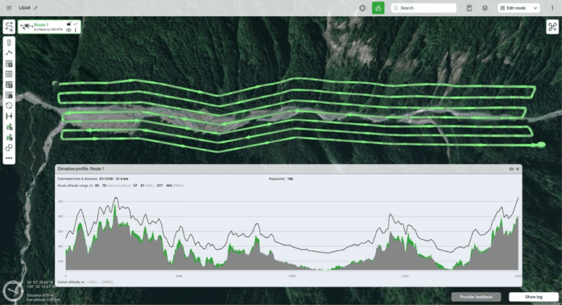
1. True 3D Mission Planning with Immersive Awareness
UgCS is more than just another 2D waypoint tool. Its immersive 3D planning environment enables you to visualize routes over actual terrain, factoring in elevation, slope, and obstacles. This shift is transformative for mapping in mountainous, urban, or other complex regions, empowering professionals to:
- Plan LiDAR and photogrammetry missions with centimeter-level accuracy
- Optimize for corridor, area surveys, and vertical structure inspections
- Import custom terrain models (DEM/DSM) and orthophoto overlays for precise route fitting
2. Industry-Leading Terrain Following
The terrain-following algorithms in UgCS are celebrated for their reliability and versatility. You can:
- Dynamically adjust altitude and slope to maintain safe distance from the terrain
- Fly close to near-vertical surfaces (consider dams, chimneys, towers) utilizing “Smart AGL”
- Import custom DEMs for local accuracy—essential in remote regions or areas beyond standard map zones
3. Unmatched Data Collection Tools
Whether executing a straightforward mapping run or a multi-payload scientific mission, UgCS automates:
- IMU calibration for critical LiDAR and magnetometer surveys
- Vertical and oblique imagery capture—ideal for creating 3D models of buildings and infrastructure
- Trajectory smoothing to protect sensitive payloads over uneven landscapes
4. Full Offline Operation
UgCS operates locally, requiring no cloud dependency, enabling planning and flying even in remote locations like Greenland or the rainforests of Papua New Guinea.
5. Multi-Drone and Multi-Pilot Support
UgCS allows for simultaneous control of multiple drones, with its Commander tool designed for large-scale operations, synchronized swarm flights, or multiple payload deployments.
“UgCS pilots are in over 100 countries, making it a top choice for professional drone operators.”
Who Uses UgCS? Real-World Applications and Case Studies
UgCS is essential for missions such as:
- Glaciology: LiDAR and photogrammetry mapping of ice mass melting and movement
- Environmental Research: Examining coastal changes, water quality, or habitat restoration
- Archaeology and Mining: Accurate topographical mapping of archaeological sites or active mining areas
- Critical Infrastructure Inspection: Vertical scans of towers, chimneys, and dam surfaces
“Janis Kuze, Director of Special Projects, reminisces about custom UgCS workflows during expeditions in Papua New Guinea’s jungles and Greenland’s glaciers—addressing rigorous technical and environmental demands.”
User-Centered Engineering: The UgCS Approach
What makes professionals loyal to UgCS amidst numerous options? It’s the user-first engineering culture spearheaded by Kristaps Brass.
Direct Feedback from the Field
- Continuous customer training: UgCS developers provide personal training, enabling rapid iterations and real-world problem-solving feedback.
- Customization: Modular software permits tailored features or integrations, even with exotic sensors or unique regulatory conditions.
Collaboration with Industry and Academia
- Geophysical survey expert partnerships for specialized workflows, like magnetic anomaly mapping with MagArrow magnetometers.
- Strong alliances with drone and sensor manufacturers to ensure hardware compatibility and future-readiness.
Key Engineering Innovations Driving the Future
1. Open Access for All: UgCS Open
In 2025, SPH Engineering unveiled UgCS Open—a free, professional-grade version of their planning suite for everyone from students to solo entrepreneurs. With UgCS Open, you have access to:
- 3D immersive planning
- Terrain-aware mission automation
- Full offline capabilities
- A built-in onboarding tutorial to speed up your learning curve
The only constraints are two routes per day and a maximum distance per route, sufficient for most users to explore, learn, and even carry out genuine missions without cost.
“UgCS Open isn’t a demo that expires in a week. You can utilize UgCS Open for actual projects, honing your skills at no expense.”
2. Circlegrammetry: A Leap in Vertical Mapping
With the introduction of the Circlegrammetry tool, UgCS transforms 3D capture of vertical structures by minimizing distortion and enhancing accuracy for assessments and modeling.
3. Automated Battery Swaps and Corridor Missions
For extensive infrastructure surveys, UgCS automates mission breaks for battery changes and can incorporate multiple corridor routes in a single session using imported KML/CSV files.
4. Seamless Fleet Management
All telemetry is documented automatically and exportable to fleet management tools for operational compliance and efficiency.
Looking Forward: Kristaps Brass on the Future of Drone Flight Planning
According to Kristaps Brass, the next chapter in drone flight planning revolves around democratization and collaboration. By offering advanced tools for free, UgCS Open cultivates a new generation of drone experts and pioneers.
“UgCS Open is perfect for experienced pilots as a testing ground—whether you’re new to UgCS or require a reliable, free tool for smaller tasks.”
Kristaps also emphasizes the importance of safety and precision: as drones take on increasingly intricate missions (from search-and-rescue to delivery), terrain awareness, route automation, and multi-drone coordination will become essential in every professional workflow.
Yes, the UgCS team is always keen on “crazy” new projects, whether in the densest jungle or atop a remote icy landscape. So, if you have an audacious idea, this is the team to approach.
Expert Tips for Drone Pilots Considering UgCS
- Start with UgCS Open for practical experience—free of risk and trial pressure.
- Utilize 3D planning features to visualize your mission before launch and address issues in the virtual sphere.
- For LiDAR operations, install custom DEMs/DSMs for precise terrain following.
- Seek assistance: SPH Engineering’s global support and training are renowned.
- Experiment with circlegrammetry for precise vertical asset mappings.
- Benefit from offline planning—perfect for field tasks far from Wi-Fi access.
Building Trust: The SPH Engineering Team and Community
SPH Engineering isn’t some anonymous entity. Their Riga-based team—comprising engineers, pilots, and trainers—builds relationships with pilots and organizations globally.
- Direct customer support, with Kristaps and his team conducting hands-on training worldwide
- Extensive partner network: Spanning over 100 countries and growing
- Trusted by prominent researchers, surveyors, and government agencies for their critical projects
Clients return not just for the software but for the human-centric approach and relentless pursuit of mission success.
Final Thoughts: Why UgCS Holds the Future
What makes UgCS engineering truly noteworthy isn’t purely its technical prowess—it’s the blend of user-centered design, unceasing innovation, and personal connection. Whether you’re a student, a veteran drone pilot, or a scientist exploring climate change, UgCS—guided by Kristaps Brass’s vision—is the toolkit you need for the next decade of drone flight planning.
Next time you embark on a drone mission, remember: achieving excellence in the sky starts with ingenuity—and compassion—on the ground.