WingtraRAY: A Paradigm Shift for Drone Surveyors
In the realm of aerial surveying, WingtraRAY is making waves, not merely raising the bar but completely reinventing it for professionals who prioritize speed, reliability, and ease of use.
Why WingtraRAY Changed the Game
For years, surveyors dealt with balancing advanced features against regulatory hurdles. Often, projects were delayed as drones required complex waivers to fly over populated areas, or due to prolonged equipment setup times. WingtraRAY eliminates these headaches with a future-proof, streamlined platform.
What Sets WingtraRAY Apart?
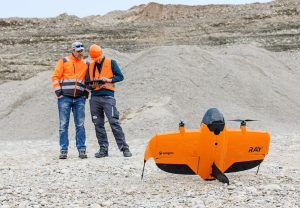
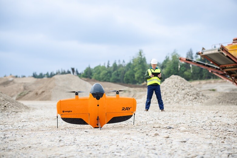
- Category 3 Operations Over People: WingtraRAY’s certified parachute allows waiver-free flights over populated areas in 98% of the U.S., with European certificates allowing for similar ease.
- Broad Payload Flexibility: Featuring six high-quality, easily swappable sensors, it facilitates transitions from LIDAR in forests to runway inspections with millimeter precision.
- One-Platform Workflow: Simply manage equipment, data formats, and deliver CAD/GIS-ready files the same day.
- Unparalleled Coverage and Speed: Quickly set up and cover vast areas in a fraction of the time traditional multirotors require.
- Next-Level Safety: Equipped with obstacle avoidance, backup systems, and comprehensive guidance for all pilot levels.
- Cloud-Connected Efficiency: With WingtraCLOUD software, expect seamless preflight checks, flight data syncs, and efficient post-processing.
Tech Specs and Clever Engineering
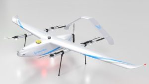
The WingtraRAY’s VTOL design enables operation from constrained sites and offers adaptive cruise speeds and extended flight times, ensuring broad coverage without frequent interruptions. Featuring advanced GNSS and PPK support, it promises survey-grade accuracy.
Cool Payloads: From LIDAR to INSPECT
The standout INSPECT payload allows for extensive mapping with impressive ground sample distances, perfect for detailed analyses in various environments. Additional payloads like LIDAR and multispectral modules provide ready-to-swap functionality for diverse needs.
The Practical Impact: Real-World Scenarios
Urban Infrastructure
A city surveyor managing GIS updates can now fly over populated areas with ease using WingtraRAY, enabling faster setup and efficient data uploads.
Airport Runway Inspection
Using the INSPECT payload, airports can conduct runway inspections with high accuracy and reduced downtime.
Mining & Quarrying
When surveying large open-pit mines, WingtraRAY outpaces traditional methods, swiftly covering extensive areas with improved safety.
Human Touch: Why Surveyors Love It
At industry events, Wingtra is known for its engineer-friendly approach, emphasizing results over hassle, with intuitive software and quick equipment adjustments.
Julian Surber, Senior Product Manager at Wingtra emphasized, “With WingtraRAY, you cover extensive areas at reduced costs, minimize revisits, and enjoy peace of mind with features like obstacle avoidance.”
The ROI Equation: How WingtraRAY Pays for Itself
Wingtra asserts that most organizations recover their cost quickly through fewer flights and simplified logistics, while reducing training needs for even novice staff.
Regulatory Approvals & Data Security
With U.S. government pre-approval and encryption standards, WingtraRAY supports secure data flow and offers air-gapped operations for sensitive sites.
The Software Edge: WingtraCLOUD
WingtraCLOUD enhances the hardware experience, offering accurate preflights, clear data visualizations, and seamless CAD/GIS integration.
Rolling Out: Availability and Expansion
Launched in July 2025 and globally available by October, WingtraRAY targets surveying firms, consultancies, and industry stakeholders seeking efficiency and reliability.
Industry Reception: Early Buzz
Valued for speed, safety, and modularity, WingtraRAY has been enthusiastically received, with users reporting exceptional support and service.
Final Thoughts: Should You Buy a WingtraRAY?
For regular drone surveying with tight deadlines and high data quality standards, the WingtraRAY emerges as an indispensable tool, combining multifaceted sensors and streamlined operations without bureaucratic delays.