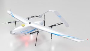
WingtraRAY: Transforming Aerial Surveying – An Extensive Overview
Imagine launching a drone in the morning and receiving precise, usable survey maps in your inbox before lunchtime. For numerous surveyors and GIS experts, this scenario is now a reality thanks to the WingtraRAY—the latest breakthrough from Wingtra, the Swiss innovator known for advancing fixed-wing vertical takeoff and landing (VTOL) drones in professional aerial mapping.
But what sets the WingtraRAY apart? Let’s delve into a practical guide tailored for surveyors, engineers, and anyone intrigued by state-of-the-art drone technology.
Why All the Buzz? The WingtraRAY Advantage
When Wingtra unveiled the WingtraRAY in mid-2025, it captured the attention of the drone realm. With capabilities like covering extensive areas swiftly, simplifying complex regulatory challenges, and offering unparalleled modularity, this drone is lauded as the “Swiss Army knife” for survey professionals.
Key Features at a Glance:
- VTOL “tailsitter” design enables vertical takeoff and landing without needing a runway.
- Single workflow: Plan, fly, process, and deliver data swiftly.
- Maps up to 550 hectares (1,360 acres) per flight—a record in survey drones.
- Up to 10x faster than traditional multirotor survey drones.
- Operates over populated areas using a certified parachute and advanced safety systems—eliminating the need for waivers in most regions.
- Automatic data sync and processing within the WingtraCLOUD platform.
- Six high-end, easily interchangeable payloads for LIDAR, 61MP photogrammetry, detailed crack mapping, multispectral imaging, and more.
The Tech Under the Hood
Design & Hardware
The WingtraRAY is a compact VTOL “tailsitter”: it utilizes its tail for takeoff and landing, transitioning smoothly into efficient fixed-wing flight. Here’s what makes it distinguished:
| Feature | Specification/Details |
|---|---|
| Wingspan | 125 cm (4.1 ft) |
| Max take-off weight | 5.2 kg (11.5 lb) |
| Payload capacity | 1,250g (2.75 lb), supporting six different sensor modules |
| Flight time | Up to 59 min (photogrammetry), 45 min (LIDAR) |
| Coverage | 550 ha/1,360 acres/flight at 120m (400 ft) AGL |
| Wind resistance | Up to 12 m/s (27 mph) sustained wind |
| Altitude | Operates up to 5,000m (16,400 ft) ASL; option for high-altitude kit |
| Transport case | 130 x 70 x 34 cm, 14.4 kg (32 lb) packed |
| GNSS | Multi-band: GPS, GLONASS, Galileo, BeiDou (redundant) |
| Battery | Dual 99 Wh smart Li-poly (UN3481 compliant) |
*Fun fact: Its manageable size and weight simplify transport between job sites—no more grappling with oversized equipment in your vehicle!*
Payloads and Sensors: Modular Flexibility
The WingtraRAY’s modular design allows for quick payload swaps, customizing each flight to meet job requirements:
- LIDAR for digital terrain models, utilities, and dense vegetation analysis.
- 61 MP full-frame photogrammetry for detailed 2D/3D maps.
- INSPECT payload for mm-resolution infrastructure analysis (e.g., airport crack detection, bridges).
- Multispectral for agriculture, forestry, environmental science.
- Thermal imaging and other specialized tasks.
This adaptability signifies that a single drone can fulfill multiple roles—a considerable cost-saving and logistical edge for survey teams.
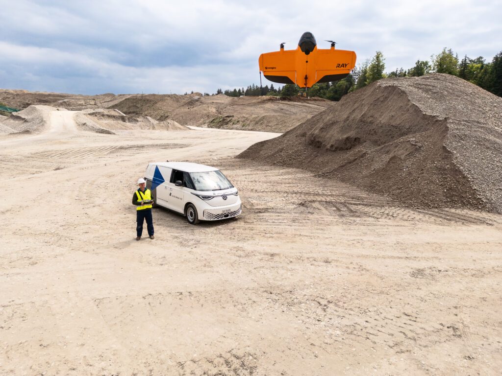
Workflow: Set Up, Fly, Deliver—Quickly
Setup & Flight
- Field setup: Typically under five minutes—no need for elaborate calibration or bulky ground stations.
- Flight planning: An intuitive app interface lets users select the area and resolution, automatically optimizing flight paths.
- Takeoff/landing: VTOL functionality requires only a small ground area, no airstrip necessary.
Speed
- Cover 100 hectares (250 acres) in just 10 minutes at photogrammetry resolution.
- Complete full data processing and delivery—often before lunch.
- Utilizes adaptive cruise speeds, up to 22 m/s (49 mph), to ensure superior image quality without missing pixels.
Safety & Compliance
- Parachute and OOP certification: Enables safe and legal flights over populated areas—ideal for urban, infrastructure, or emergency mapping.
- Obstacle avoidance & redundancy: Provides reassurance for pilots regardless of experience level.
Data Handling
- Automatic geotagging, file syncing, and processing: Eliminates manual SD card swaps or file conversions.
- WingtraCLOUD integration: Select output coordinate systems and receive CAD/GIS-ready files directly, minimizing manual errors.
“We built WingtraRAY to remove the barriers surveyors face every day. Fast, safe, and extremely flexible—giving you the freedom to say yes to more projects.”
— Julian Surber, Senior Product Manager, Wingtra
Who Is This Drone For?
Ideal for anyone needing swift, dependable, highly accurate aerial data:
- Land surveyors covering vast terrain or construction sites.
- Civil engineers monitoring infrastructure progress, highways, or rail projects.
- Agricultural consultants performing crop health assessments or soil analysis.
- Mining and resource companies measuring stockpiles, pits, and expansion zones.
- Government and municipalities surveying urban areas or disaster sites.
- Inspection professionals inspecting roofs, bridges, and runways for defects or hazards.
How Does It Compare? Drones vs. Traditional Surveying
Comparing drone surveying (with WingtraRAY as a benchmark) to conventional methods:
| Aspect | Traditional Surveying | Drone Surveying (e.g., WingtraRAY) |
|---|---|---|
| Setup time | Hours: tripod, station, crew | Minutes: one-person operation |
| Coverage | Dozens of acres/day | Hundreds to 1,000+ acres/flight |
| Manpower | Large teams | Solo or two-person team |
| Data Speed | Days/weeks to process | Live preview, data ready same day |
| Safety | Exposure to hazards | Remote operations, safer in all conditions |
| Accuracy | Highest for tight legal tasks | 3cm (0.1 ft) absolute, meets most needs |
Bottom line: The WingtraRAY delivers survey-grade results in a fraction of the time, with reduced risks and costs. It’s a win for the majority of survey tasks.
Real-World Examples & Case Studies
1. Airport Runway Crack Detection
Using the INSPECT sensor, WingtraRAY mapped 100 acres at millimeter resolution, identifying cracks invisible to the naked eye—essential for safety and maintenance scheduling.
2. Mining Volumetrics
A mining crew transitioned from weekly ground teams to flying three times weekly, significantly reducing data collection time and costs by 40%.
3. Emergency Urban Mapping
Following flooding, a city’s response team utilized WingtraRAY to rapidly create 3D models of affected neighborhoods, facilitating quick decision-making and resource distribution.
4. Large-Scale Forestry Survey
Foresters employed the multispectral payload to map 500 hectares in a single flight, promptly identifying disease spread and planning interventions.
Expert Tips: Maximizing Your WingtraRAY
- Pre-plan flights in the app—it optimizes routes for both sensor coverage and battery efficiency.
- Swap payloads on-site—immediately adapt to new project demands without downtime.
- Utilize WingtraCLOUD for smooth data processing and precise georeferencing.
- Use the parachute system to unlock projects over people—urban surveys, infrastructure inspections, etc.
- Stay updated—Wingtra provides regular firmware and feature upgrades for enhanced performance.
Frequently Asked Questions
Q: How does WingtraRAY manage strong winds or high altitudes?
A: It withstands winds up to 12 m/s (27 mph) and functions at altitudes up to 5,000m (16,400 ft) ASL. Additional high-altitude kits are forthcoming.
Q: Do I need a waiver to fly over towns or populated areas?
A: In most regions (including 98% of U.S. territory and under EASA STS-02 in Europe), the certified parachute allows legal flights over people without special waivers.
Q: What about data security?
A: Entire processing can be local; internet is only required for map downloads and firmware updates.
The Team Behind the Drone
Wingtra is deeply Swiss—precision engineering fused with practical fieldwork. Their team combines robotics PhDs, field engineers with global experience, and a commitment to user-centered design. Their ethos: “Craft drones that are like robust tools, not gadgets.”
Customer feedback consistently praises their responsive support (“After a calibration issue, Wingtra not only called back but guided us step-by-step and checked in later. That’s rare!”).
The Future of Professional Surveying
The WingtraRAY launch emphasizes a shift in professional surveying:
- Multi-payload drones are becoming standard.
- Integrated workflows reduce error and friction.
- Compliance and safety (OOP, parachute, redundancy) are essential, not optional.
- AI-driven analysis and automated reporting are near future trends.
- Increased demand in sectors like construction, energy, insurance, and government for quick, actionable aerial data.
Is It Time to Upgrade Your Surveying Equipment?
If you’re contemplating a drone purchase for surveying, seeking the best mapping drone, or requiring aerial data that meets tight schedules and budgets, the WingtraRAY is a significant contender. Its blend of speed, versatility, safety, and data precision arguably makes it a “superhero’s suit” for surveyors.
And for those who fondly recall hoisting theodolites and steel tapes: perhaps it’s time to let robots handle the heavy lifting, enabling you to concentrate on what truly matters—analyzing, deciding, and building.
P.S. Still undecided? Keep this in mind: Batman would certainly deploy a drone like WingtraRAY for Gotham’s surveying needs. But you don’t need to await a bat signal—schedule a demo, and witness this Swiss marvel in action.
Survey smarter, ascend higher, and let your data convey the narrative—the future with WingtraRAY is now!