DroneSense and MatrixSpace Partner to Expand BVLOS First Responder Operations: An In-Depth Guide
The fast-paced advancements in drone technology are continually redefining capabilities for emergency services. The innovative partnership between DroneSense and MatrixSpace represents a significant step forward, enabling first responders to conduct BVLOS (Beyond Visual Line of Sight) drone operations, thereby transforming public safety. This guide delves into the implications of this collaboration, the changes it introduces to drone as first responder (DFR) programs, and its importance for agencies, communities, and the broader UAV industry.
The New Era: How DroneSense and MatrixSpace Are Shaping BVLOS Public Safety
Why BVLOS Matters
Traditionally, drones used in emergency services faced restrictions due to regulations requiring operators to maintain visual contact with the aircraft—a measure for safety that limits their operational scope during real-life situations.
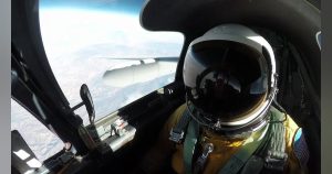
By enabling BVLOS, drones can achieve their full potential: providing real-time situational awareness, quicker response times, and the capability to operate in challenging or hazardous conditions—*even in the dark* or during low visibility. Whether it’s locating a lost hiker in a dense forest, fighting a fire spreading through urban blocks at night, or dealing with a rapidly unfolding natural disaster, the ability to see beyond the operator’s sightline is crucial and transformative.
However, implementing BVLOS operations is complex: it requires airspace awareness, collision avoidance, adherence to strict FAA regulations, and seamless integration of both hardware and software.
The Partnership: Building the Next-Generation Drone Solution
DroneSense, well-regarded for its robust public safety management platform, has teamed up with MatrixSpace, a leader in radar technology. Their partnership aims to:
- Integrate MatrixSpace’s real-time radar detection capability directly into the DroneSense mission management system.
- Offer a turnkey solution for DFR programs aiming to conduct BVLOS operations safely, efficiently, and legally.
- Promote “layered” safety, combining radar, software, and established flight protocols to meet or exceed federal airspace safety standards.
This approach is not just theoretical—it’s currently operational in police departments, setting new benchmarks in the field.
Key Features & Benefits of the New Solution
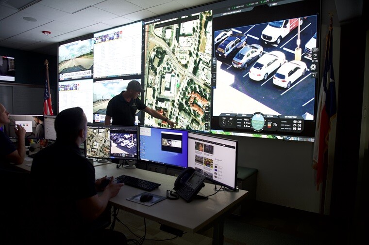
- Real-time radar object detection: DroneSense OpsHub and Remote operator interfaces now incorporate MatrixSpace radar feeds, allowing for the display of nearby aircraft (including planes, helicopters, drones) as live tracks—all within a single, unified command interface.
- Automated threat classification: The radar system not only detects but also classifies potential threats, enabling pilots to identify and respond to approaching objects swiftly and informedly.
- Enhanced operational scope: Agencies can now oversee much larger areas. In Palm Springs, for instance, the police drone program covers 37 square miles using radar, eliminating the need for human spotters—the most extensive DFR radar-supported area in the US.
- FAA-approved operations: In a groundbreaking development, the Campbell Police Department became the first in California to receive authorization for single-operator BVLOS missions under a Part 91.113(b) waiver thanks to radar integration.
- Operation in night and low-visibility conditions: MatrixSpace radar remains functional regardless of weather or lighting, facilitating missions in poor weather, darkness, or smoky conditions.
“This partnership is a game-changer. It delivers crucial situational awareness to real-time crime centers, fusion centers, and command staff through a single mission platform.”
Real-World Examples: How Agencies Are Using the Technology
- Search and Rescue: During floods along the Guadalupe River, drones offered lifesaving visual assessments to otherwise unreachable victims, extending the scope beyond a pilot’s line of sight across vast, risky areas despite visibility challenges.
- Law Enforcement: With real-time radar overlays, crime centers can coordinate multiple drones, assessing evolving situations—such as street pursuits, hostage scenarios, and crowd control—without risking collisions or losing drones.
- Firefighting: Drones are capable of penetrating smoke-obscured environments or hazardous firegrounds, sending vital data back to incident commanders unhindered by darkness or visual obstacles.
Why Ground-Based Radar Is a “BVLOS Enabler”
In traditional settings, drones rely on cameras and on-board sensors for collision avoidance, which can be limited in dense airspaces or when obstacles aren’t visibly apparent. Ground-based radar bridges this gap—providing an extended field of view, operating in adverse weather, and offering a continuous 360-degree airspace overview.
MatrixSpace’s radar technology includes:
- 4D telemetry (location, altitude, heading, and speed)
- Real-time 360-degree scanning capability
- Automated classification of air objects
- Seamless integration of data into DroneSense’s operator displays
The outcome: Agencies can adeptly detect, identify, and avoid potential conflicts, which is crucial for safe BVLOS operation and obtaining regulatory approval.
How Does It All Work? (A Quick Technical Tour)
- Radar stations are strategically positioned to cover vital zones—police districts, city centers, or sensitive infrastructure.
- Drones are launched—remotely or otherwise—being continuously tracked by MatrixSpace radar to follow their position and any aircraft within the vicinity.
- Data is transmitted in real-time into DroneSense software—displaying radar detections, video feed, mission telemetry, and commands on a unified interface.
- Operators and supervisors are presented with a “common operating picture”: all threats, assets, and clear airspace awareness with no blind spots.
- Should a non-cooperative aircraft enter the airspace (such as a medical helicopter, a small plane, or a hobby drone):
- An alert is triggered.
- The operator may choose to pause or recall the drone.
- Mission logs are archived for auditing and compliance purposes.
Compliance and Legal Breakthroughs: FAA “Greenlights” the Future
Previously, BVLOS operations faced regulatory obstacles, as the FAA required a human ‘see-and-avoid’ component. Through this partnership, agencies have demonstrated that radar-enabled, software-integrated DFR programs can maintain or exceed the safety levels of traditional visual observer setups.
- Campbell Police Department’s waiver sets a new benchmark, paving the way for more agencies to secure Part 91.113(b) approval, backed by “layered safety” (combining radar, procedures, and technology) to meet stringent regulatory criteria.
- Palm Springs’ extensive DFR coverage serves as an exemplary model for urban drone public safety initiatives, expanding through scalable radar to enhance both capacity and reliability.
What Sets DroneSense & MatrixSpace Apart?
- Open ecosystem: DroneSense’s dedication to integrating an array of hardware options (radar, aircraft, sensors) helps agencies future-proof their technological infrastructure.
- Human-centered workflows: Interfaces are designed by and for first responders—offering practical utility beyond simple technological features.
- Proven expertise: Success is not limited to pilot projects; real-world deployments with high-profile agencies showcase concrete achievements.
“We’re delivering a turnkey radar and software solution geared for next-generation airspace awareness—including during night operations and in low visibility.”
The Way Forward: Trends, Tips, and What to Watch
Trends to Watch
- Increased adoption of BVLOS: Following successes in areas like Palm Springs and Campbell, more U.S. agencies will seek waivers and radar-enhanced programs.
- Enhanced data fusion: AI and analytics integrating radar and video data will optimize decisions, automate warnings, and eventually support autonomous missions.
- Expansion of nighttime and adverse weather operations: Growth in sectors such as firefighting, disaster response, and critical infrastructure monitoring, beyond just law enforcement, is expected.
- Public–private partnerships: As agencies experience the benefits of integrating radar and software for DFR, collaborations with tech startups and established vendors will likely increase.
Expert Tips
- Early engagement with regulators: Demonstrate how your solution maintains federal safety standards using concrete operational data.
- Start small, scale smart: Begin with limited deployments, compile records, and establish a strong operational safety framework.
- Training for remote operations and incidents: Comprehensive situational awareness is critical not only for drone operators but also for commanders and analysts to effectively respond to airspace events.
Customer Success Story: Palm Springs PD’s “Eyes Everywhere”
Challenge: Palm Springs faced the need to improve coverage for rapid incident response, but the city’s size and resources made traditional observer networks unattainable.
Solution: Utilizing DroneSense and MatrixSpace, they implemented ground-based radar stations with fully remote pilots, covering 37 square miles round-the-clock without requiring ground observer manpower, all while complying with FAA guidelines.
Impact: Response times have drastically decreased, officer safety has improved, and community trust has grown due to transparent and automated airspace management.
The Human Side: Why First Responders Are Excited
Behind the technological interfaces and radar capabilities are individuals such as dispatchers, pilots, and command staff whose work has become safer, less stressful, and more efficient. Public safety drone teams increasingly view themselves as digital pioneers, using technology to enhance their reach and protect lives more effectively, with reduced risk.
In situations ranging from rescue operations in Texas floods to late-night urban surveillance, operators express a newfound confidence: “We have complete awareness of what’s in the sky—we never fly blind.”
Final Thoughts: The Next Frontier
The strategic partnership between DroneSense and MatrixSpace marks a significant milestone for *BVLOS drones in emergency responses*. For agencies looking to equip themselves with drones for maximum operational impact, this turnkey solution—which integrates radar, management software, and FAA-compliant workflows—addresses major concerns related to operations, compliance, and safety.
First responders are no longer limited by what they can see. Through effective partnerships and ongoing innovation, the sky indeed is not the limit—it signals just the beginning.
*Interested in transforming your agency’s drone program? Request a demo and learn from trailblazers making DFR safe, scalable, and unstoppable.*