US Army Corps of Engineers Utilizes SimActive’s Correlator3D for Coastal Corridor Mapping
Published on March 20, 2025, by Miriam McNabb
The United States Army Corps of Engineers has recently deployed SimActive’s Correlator3D software for effective corridor mapping. This advanced imaging processing tool assists in creating mapping products in conjunction with topo-bathy LiDAR systems.
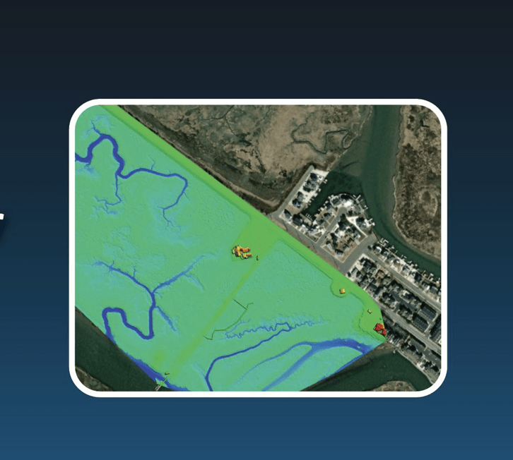
The Joint Airborne Lidar Bathymetry Technical Center of Expertise (JALBTCX), part of the Corps of Engineers, employs cutting-edge sensors and mapping technologies to accurately document the vast coastline of the United States. As highlighted in SimActive’s press announcement, the collection of imagery is facilitated using a Phase One 150MP camera alongside topo-bathy LiDAR systems. The LiDAR data generates surfaces that are then integrated into Correlator 3D with the imagery, enabling the rapid production of orthomosaic blocks suited for various assessments.
J. Heath Harwood, Physical Scientist at the US Army Corps of Engineers, praised Correlator3D, stating, “Correlator3D is by far the easiest to use and fastest imaging processing software available. Its DEM editing and mosaic editing tools are exceptional.”
In a previous interview with DroneLife, Simactive’s CEO, Philippe Simard, elaborated on the military applications of Correlator3D. He noted, “Initially, the Canadian army sought a more streamlined photogrammetry suite for training personnel during their missions in Afghanistan. This led to our contract to develop a solution that was both simpler and faster for military needs.” The rapid processing capabilities of Simactive align well with military requirements for swift and intuitive mapping, applicable to both infrastructure projects and field operations.
Recently, Simactive unveiled the version 10.3 of Correlator3D, which emphasizes optimizations for handling larger mapping projects—ideal for the requirements of the Corps. Louis Simard, CTO at SimActive, remarked, “The enhancements in Version 10.3 significantly improve user experiences with substantial datasets, facilitating the processing of even larger projects.”
More information regarding Simactive and their Correlator3D software can be accessed here.
For more drone news delivered to your inbox each weekday, sign up here.
Related Articles
- Enhancing Drone Mapping with RTK and PPK: Insights from SimActive’s Eric Andelin
- SimActive and Air Data Solutions Enhance Oil & Gas Mapping with High-Resolution Aerial Imagery
- SimActive’s Correlator3D™ 10.3: Revolutionizing Large-Scale Mapping with Enhanced Speed and Flexibility
Attribution: Original Article